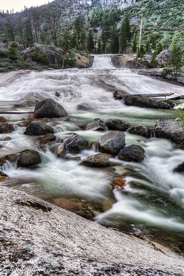
I was up at sunrise and made the short walk down from my tent to photograph the final waterfall of my trip: Lower Rancheria Falls. At 91 ft. high, the lower falls is a glorious fanning waterfall cascade and slide. It is certainly my favorite of the waterfalls here at Rancheria. After enjoying the waterfall I climbed back up to my campsite, packed up and made my breakfast and coffee.
For me, being here on Easter was both glorious and melancholic. I missed being in church and playing my favorite Easter song which we essentially only sing once per year (I play drums in the band). On the other hand, what better day and place to delight in the beauty of God’s creation.
I could, of course, worship God beside the beautiful waterfall by reading the resurrection story on my Bible app. But wait, no I can’t! Because my stupid phone was not working! I could not open any apps on my phone. Although they are supposed to work offline with no cellular service they just would not open. I could not send messages to my wife. I could not view my maps. I could not watch Netflix. I could not read my Bible. This could have been a serious problem if anything went wrong on this trip. Thankfully, everything went perfectly fine. I was able to open my Music app so at least I could play my favorite Easter song.
I found one more waterfall to photograph on the hike back home. Tiltill Creek Falls was still in shade when I got there so I decided to stop. I was not planning to but hey, why not. I found a much better spot to photograph this waterfall. I won’t say if I was or was not standing in a very dangerous spot while doing so. (in case my wife is reading this)
It was a four hour hike back to the Hetch Hetchy trailhead and I thought I made good time. That is, until I was passed by a couple tall hikers. I am not short but I do wish I had longer legs so I could hike faster. These people just cruised by me and I could not keep up with them. I arrived back at the car at 12:30PM and drove straight to Pizza Factory in Groveland. It was a glorious 3 day trip to Rancheria Falls at Yosemite National Park.
At 3PM I started my hike up to Tiltill Valley. Again, I anticipated it would take 1.5 hours to climb 3 miles with 1000 ft. elevation gain. This time I was close to spot on, but it is a grueling hike. I counted 30 switchbacks. It was relentless. A girl coming down the mountain said the trail flattens out ahead. She lied. Only in the last half mile or so once you reach the meadow does it actually flatten out.
Tiltill Valley meadow is a swampy mess that you must cross. There are no two ways about it, your feet are getting wet. I quickly gave up trying to find a way around the swamp and just splashed right through it. The water was up to my ankles or thereabouts and it was not difficult, just wet and very cold.
You can see Upper Tiltill Creek Falls from the trail and there is a faint path from the trail up to the waterfall. Obviously people have been here before. I was surprised about this. I was expecting another completely hidden and unknown waterfall discovery. Yet even though people may have been here no one has ever documented it before. I am the first.
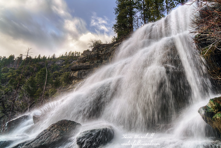
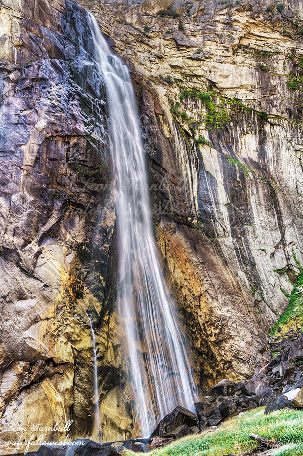
This is surprising because Upper Tiltill Creek Falls is a fantastic waterfall, 88 ft. high in two tiers, and it is not difficult to reach. It is, however, very difficult to photograph. There is a ton of brush at the bottom and there is no place or angle I could find to photograph the bottom tier of the waterfall. The creek was not easily crossable but I don’t think the other side would have yielded a better viewpoint anyway. I settled on just photographing the upper (bigger) tier of the falls. You can climb right up to the upper section and it is right in your face with the refreshing mist washing over you. It is a very cool spot. There is a big drop-off right below you as you stand on the slick rock but let’s not worry about that. For now. A little newt beside me was also enjoying the refreshing waterfall as I waited for the sun to go behind the hillside.
The waterfall came into shade at 6PM right on schedule. I took my photographs and then very carefully climbed back down from the upper tier. Back on the trail, I had more time than I did the previous night but once I hit the big downhill section, I jogged all the way down the mountain and I arrived at my camp right at sunset. It was a perfect afternoon in Tiltill Valley at Yosemite National Park.
It was about 40 degrees. It was cold but I slept ok.
I got up early and walked up to Rancheria Falls. I saw my first bear of the year walking up the trail on the other side of the bridge just above the falls. It was a bit far away but I did get some video of it. I wondered if he had crossed over on the bridge. That would have been a cool sight to see. If only I had gotten up 10 minutes earlier.
I got down to the bottom of Rancheria Falls on the other side. There is a lot of poison oak near the bottom and last time I balked at it, but this time I made it down and avoided touching any of the oak (I hoped). There was a lot of mist but I was able to get some good shots of the waterfall from this spot and I ate my breakfast here.
I returned to camp and made some coffee and then settled in for the long wait. Six hours I had to waste before I could start my big afternoon hike. Sigh. What could I do? Basically I had a 6 hour nap without doing much in the way of napping. It was a lovely morning at Rancheria Falls in Yosemite National Park.
The return to Yosemite National Park. Rancheria Falls at Hetch Hetchy Reservoir. My goal: bag the two waterfalls I missed the first time I went to Rancheria. It was Good Friday.
The first time I went here I was injured and had to cut my trip short. This time I would get to these new waterfalls. Surely? I made a wrong turn on the drive to Yosemite. This was a bad omen. I have driven this road a hundred times and have never done that before. I was five miles down the road before I realized something was wrong. Duh.
I arrived at the park entrance at 7:45AM. There was no one at the kiosk. Huh? Is this due to budget cuts or something? That is just horribly stupid to let everyone in for free because of budget cuts. This is the main source of income for the park! I feel that the park service does (and has always done) a poor job managing the resources that they have been given. I can give many examples but not right now. Let’s get hiking.
There was only one other car in the backpackers parking lot. I wondered if I’d see him (or her) at Rancheria Falls. That would be fine with me just so long as he was not camping at my secret spot. Otherwise blood might be shed. It was Good Friday after all. (kidding of course, but read on …)
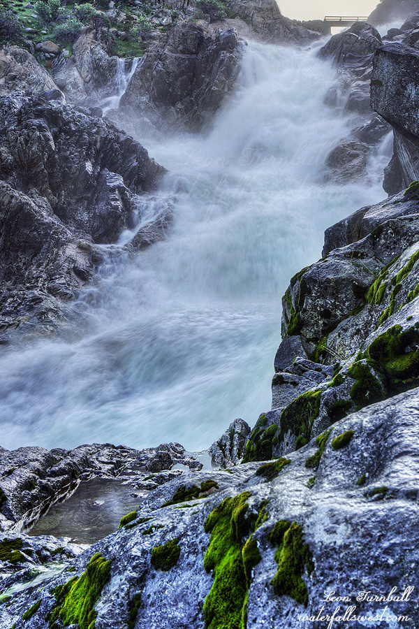
The snow melt was probably the same or a bit higher from the last time I went to Rancheria Falls. Tueeulala Falls was looking sad and I was surprised, I was expecting a lot more flow in it. It was very misty crossing the bridge at Wapama Falls but it was not overflowing onto the bridge. It looked like they had just recently rebuilt some of the bridges at Wapama. Interesting. You would think that if they were going to do that they would build them higher so the water never overflows onto the bridge making it too dangerous to cross (or re-damaging it). Of course they did not do that.
After Wapama Falls I saw no one until I arrived at Rancheria. It was noon, my secret spot was available and there was no one else around. There was no shade, however. I was certain I remembered shade when I was here before. One hour later a couple guys came strolling up, clearly wanting my campsite. This is my spot! Thankfully, they moved on to somewhere else and I never saw them again. No blood was shed on this day. Except for Jesus’ blood on the cross when He died for you. Do you know this?
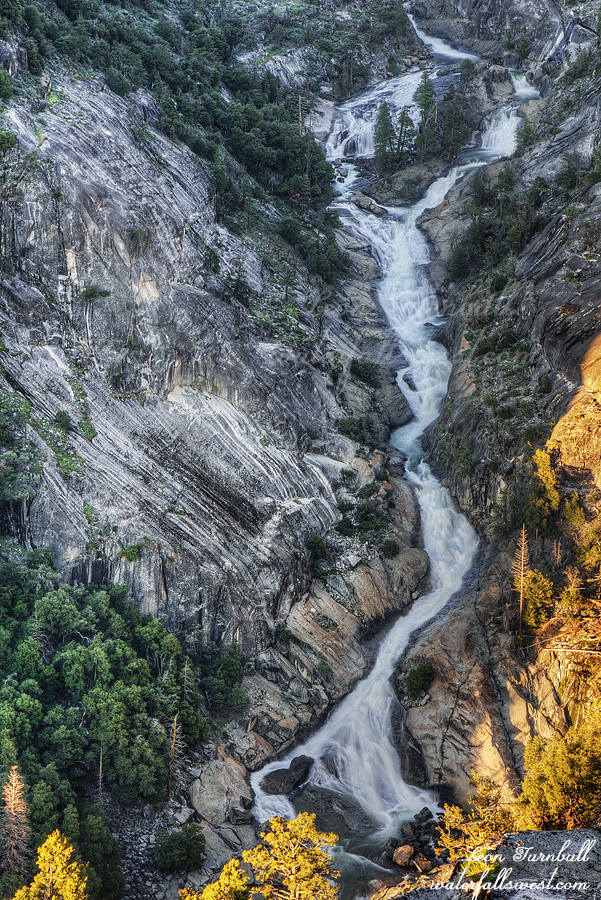
I massively underestimated the hike to my first waterfall in the afternoon. It was 3 miles with 1500 ft. elevation gain. It would not take more than 1.5 hours. Surely? It took 2 hours and 15 minutes. Getting down to the viewpoint from the top of the ridge was a lot more difficult than I thought. I arrived just before 7PM and it was extremely cold from the wind at this exposed location along the cliff. The waterfall was supposed to be in shade at 7PM but it was only partially in shade. By 7:10PM I took my photos and packed it up, I could not wait any longer. I would be hiking back in the dark as it was. I think I got a pretty good photo, anyway.
Upper Rancheria Falls is a massive 330 ft. high cascade. It is spectacular and the viewpoint is magnificent. I feel grossly under appreciated in finding these incredible waterfalls in Yosemite National Park. I am sure no one has ever seen this one before. It is off the beaten track and who would even know it is here? Hidden away, in canyon deep.
Once back on the trail I ran all the way back down until it got too dark after which I got my headlamp out and walked the rest of the way. I saw a couple bats flying around me and one came within two inches of flying right into me before veering off at the last milli-second. You may be blind but come on, that is a bit too close for comfort. I arrived back at camp and went straight to bed. It was a very good day in Yosemite National Park.
How many bucket list waterfalls have I been to this year? One, two, three, four. All of them in Yosemite National Park: Eleanor Creek Falls, Ribbon Falls, Kendrick Falls, and … doo doo doo doo … bottom of Illilouette Falls. Four is quite a lot for one year, right? Obviously I’ve been on many other hikes, but I am talking about bucket lists, once in a lifetime hikes, at the top of my list.
I think I have probably mentioned before that I hate the new system in Yosemite where you need to get a day permit reservation in advance. That may work for some people but not me. I cannot plan months in advance when I am going to Yosemite on a certain random day in the future. I usually plan my hikes last minute. I don’t know what the weather is going to be like months in advance, or when I will be able to go on a certain hike, or even what hike I want to do until a few days before. They do release additional permits one week ahead of time, however, on Saturday I am usually hiking so I cannot log on to the computer and try and get a permit in the 10 minutes they are available before they all sell out. This past week, however, I was not doing anything on Saturday so I was actually able to log on and snag a day permit for the following weekend. Goodness gracious me.
I have often wondered why they say you need a permit at 5AM. It is so early! I could go in to the park before 5AM without a permit but that would mean I would have to drive to Yosemite Friday night and find a place to camp or sleep in my car. I don’t really like doing that too much. After 5AM you need to have that darn permit. I arrived at the gate at 5:55 AM. Permit in hand. The kiosk booth was not open! There was no one there! I suspect now that they do not even open until 6AM at the earliest. So why do they say 5AM? Next time I would not even need a permit. Would it be worth taking that chance? Hmmm.
There were a lot of people in the Valley. The Curry Village parking lot was completely full. The trailhead parking lot was almost full. It was only 6:30 AM! Holy crikey.
I got my stuff and headed up the trail. I thought the Ribbon Falls hike was very tough (it was). This hike was about three times as difficult. It is about the same length and about the same elevation gain, just a little more. But there is no trail! (unlike Ribbon). It is all off trail. There is brush. There are creek crossings. There is walking right up the creek bed. There is scrambling over huge boulders. There are a couple technical class three maneuvers to get over the huge rocks. It was at the limit of my skill level. It took 2 1/2 hours up and the same going back down. But I made it. The bottom of Illilouette Falls! I would not say it was spectacular but I would certainly say it was incredibly beautiful. (it would be spectacular at high flow but it’s not possible to do this in the spring). Bonus: I saw zero people. Everyone else was hiking the Mist Trail. It was a fantastic morning in Yosemite National Park.