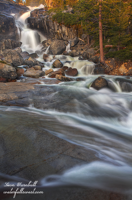
South Silver

On Saturday afternoon I was leading a private workshop up on Ice House Rd. Our first stop was South Silver Creek at Ice House Reservoir. The light was crappy when we arrived (as anticipated) so we just worked on various techniques of dealing with the high dynamic range and compositions. There are not a lot of options at this particular waterfall for composition but for some reason I really liked the little nook in the rock here at the edge of the cliff and personally I worked it to death while my client moved around the area as best he could.

After spending time here we climbed up to the top of the cliff where we could see more small waterfalls called the Teacups. We saw a couple people up there and I was wondering what they were doing. Then I realized they were kayakers! We watched them come down the Teacups and stop at the top of the big waterfall. We thought they might come down the big waterfall so we hurried back down hoping to get some shots of them coming down it. South Silver Creek Falls is 64 ft high. It seems crazy but kayakers have come down this one before. These guys, though, after taking a long look at it decided not to descend. Bummer! I was not sure the reason but I was thinking it might have to do with a huge log at the bottom of the falls. As I found out later, one of the kayakers was actually someone I knew. He said the flow was just too high to do the big waterfall. Seems quite logical to me.

In the meanwhile the waterfall came into the shade so we spent a lot more time shooting the falls here and some smaller waterfalls on the creek before moving on to Bassi Falls for sunset. We spent more time here than I had planned but it really worked out well I thought. Sometimes you just need to go with the flow.

2 Comments

Feel the Roar

I went up Ice House Rd again, on the evening of “Rapture Day”, driving all the way to Loon Lake (if indeed there was going to be a rapture, I wanted to be “caught” doing what I loved – haha). There was still quite a bit of snow up there and ice on the lake. Still too much snow to do the hike I had planned so I drove back down to Bassi Falls.

There was no snow at this lower elevation so I was optimistic that I would be able to drive all the way into the trailhead. And indeed I could! A lot of other people also seemed to have the same idea this weekend. There were a lot of people hiking back up the trail as I hiked down to the falls but there was no one else at the falls once I arrived, so I scoped out my spot to wait for the sun to set as it was still early in the evening.

Bassi Falls is a spectacular waterfall in the spring when the snow is melting and is one of my fav waterfalls in the Sacramento area and also very easy to get to. I come here at least once per year. As I waited I took some video of the falls, not something I normally do, but may do (should do) more of in the future, now that I have HD on my new camera (I posted the video on my waterfallswest facebook page).

Another family arrived at the waterfall, a photographer with his wife and two kids. The wife ran up to the top of the falls while the kids ran around like gangbusters playing in the creek with no supervision, while the photographer took his pictures. With the creek flowing so crazily, I didn’t think this was particularly safe as the kids were even crossing the creek. I guess it was safe enough where they were doing it but I don’t think I would want my kids crossing there. Something easily could have happened and he was too far away to help. Just my opinion. Later the wife came back down and then they were supervised more closely. Anyway, they stayed quite awhile but then left just before the light on the waterfall got nice, which happens just as the sun dips below the ridge line, and only for a very brief time. If he would have waited ten more minutes, he would have had a nice photograph. I’m just sayin.

2 Comments

White Hall

This is a new waterfall I found a couple weeks ago on my outing to Mill Creek Falls. I had no idea this waterfall was here, but saw it as I hiked down the road. After visiting Mill Creek Falls, I went down to this one on the way back. It was harder than it seemed. No trails went down to it, and the going was quite brushy, especially as I got close to the creek. Nonetheless, there was a bit of a path, and I pushed through the brush to get down to the waterfall. It is a fairly nice waterfall, 41 ft. high, though a good viewpoint of it was hard to come by.

I am looking forward to this weekend, as I am making a whirlwind trip to Yosemite. The waterfalls down there should be smokin. And I am hoping to get to quite a few new ones that I have not been to before as well. It  will be a fun and a very fast trip.

http://waterfallswest.com/waterfall.php?id=1654

No Comments

Difficult

This morning I went on a hike back up on Ice House Rd. This is my third time already up there on Ice House this spring, and I plan to be going up there many more times. It is one of my favorite hiking areas in the greater Sacramento area. There are so many areas to explore, and many waterfalls to find. This is what I was doing this morning: exploring to find new waterfalls. And I found one indeed. But it was certainly a difficult one.

When I was up at Jay Bird a couple weeks ago, I had initially planned to explore into Round Tent Canyon. But there was still too much snow at the top of the canyon. I could have snowshoed in, but it would have been a difficult 9 mile snowshoe hike, and I did not want to do that at the time. I returned here this morning, two weeks later, and most of the snow was gone! I was able to drive in on the road a half mile, but then got stopped by a snow mound. I would have to hike the rest of the way, but that was fine. I would not need snowshoes, so it would not be too difficult. At least the first part of the hike was not difficult, anyway. It was certainly a pleasant hike along the road paralleling Round Tent Canyon. The creek, starting out as a small little stream, picked up speed as it continued on, getting more water along the way from side streams and melting snow. The steepness of the canyon also picked up steam along the way, getting steeper and steeper, and much steeper. I was definitely wondering if I would be able to get anywhere near a waterfall, if indeed there was even one.

I had no idea, really, if there was a waterfall in Round Tent Canyon. After examining my topo maps, it looked like there “might be” a 50 foot high waterfall in there somewhere, at a certain spot. As I got down to that certain spot, though, it required getting off the nice mellow road, and getting down and dirty in the midst of the forest. The terrain was now very brushy, very steep, and very difficult. I had really hoped that the terrain would not be so brushy, as I had quite a ways to go still, down to the waterfall. No such luck on that one. I persevered however, and came down to a spot which was close to where I anticipated a waterfall to be, and found just a small 20 foot waterfall. I looked downstream, and saw the terrain seemingly flatten out, so this must be the only waterfall down here after all.

I made my way down the steep mountain to try to get to the bottom of this 20 footer. It was as messy as anything I have ever seen. Huge trees fallen all over the place at the base of the waterfall. There was no way I could get up to it to take a photo. It looked though, that I might be able to get up to it if I crossed the creek. I did not bring my water shoes, and I really did not want to do this, so I debated amongst myself, and finally decided that I should cross since I came all this way and this was the only waterfall down here. After crossing, I found that I was able to get up to the falls, but I was too low! I could only see the bottom 10 ft. section, and could not see the top of the falls from this spot. There was no other viewpoint. I crawled under the huge logs spanning across the creek, which is something that kinda freaks me out. What if the logs all of a sudden collapse on top of me? I have the same issue when driving and I get stopped under an overpass or something. What if there is an earthquake when I am under there? Anyway, I buckled up my courage and crawled under there to take a photo anyway. The logs did not collapse, and there was no earthquake.

So after all that shenanigans, I crossed back over the creek and started my climb up the mountain. But fortunately, I took a closer look at my map, and I realized that I was not really even close to where I had thought the waterfall should be. I had better continue on downstream to see if there might be yet another waterfall down there. When would I ever be back in this canyon? Never. So more difficult cross country and bushwhacking brought me down to yes, the 50 ft. high waterfall that I anticipated getting to in the first place. Indeed I measured it to be exactly 50 ft. high, though it looked to my eye that it was actually quite higher than that. It was another steep descent down the mountain, and I could not get all the way down to the bottom due to a sheer dropoff, but I crawled up on a rock on the side of the cliff, and was able to take this photo of it. Getting any closer or a better angle would have been far too dangerous.

After that it was just a matter of climbing back out of the canyon and back to the road. It was difficult and it took awhile, but I finally made it back to the road. Thanks to my GPS that works so well under tree cover, it would have been almost impossible to find my way back otherwise. Maybe. Once back on the road, I made the long, slow, (and easy) journey back to my vehicle parked near Ice House Rd. It was a crazy day, but I was so pleased that I found this new waterfall deep within Eldorado National Forest.

More info on Round Tent Canyon Falls:
http://www.waterfallswest.com/waterfall.php?id=1663

No Comments

Foggy Falls

As I drove up Hwy 50 in the early morning I encountered some very intense fog. I literally could not see 10 feet and I had to slow down to under 10mph. Seriously is it April or January? The only other time I remember fog so thick was driving up the Malahat out of Victoria BC. As I approached Pollock Pines I stopped at the Shell station there. Making friendly chit chat, the lady there put me in my place. “You think this is bad? This is nothing. Sometimes you cannot even see the tulips just outside the window there.”. Well what she said may be true but in my defense it was not quite so foggy right there in Pollock Pines as it was on the highway around Camino which is where I had to slow right down.

Regardless, my primary concern at the moment was that I might not even be able to SEE the waterfall I was planning to go to. My plan was to shoot Mill Creek Falls from across the canyon, not go right up to it. It would be pointless to go on a six mile hike and then not even be able to see the waterfall. Did I get up out of bed for nothing? Should I turn around now and go home?

I decided to just drive up to Ice House Rd and make my decision once I got there. When I arrived at the trailhead the fog had dissipated enough that I thought it would be good to proceed on the hike. But as I got ready to start hiking, within five minutes the fog rolled in again. Oh and it started raining too. Nonetheless I continued on.

As I hiked down the road I also had a pleasant surprise. I found a bonus waterfall which I could see from the road on White Hall Creek. It was off the main road though so I decided to try to get down to it on my way back (which I did – I LOVE finding new waterfalls).

Mill Creek Falls is not a new waterfall. I have known about it for a long time. You can see it in the spring from Ice House Rd off in the distance. You can sort of see it from Hwy 50 at White Hall. But getting to it is a problem. My friend (no names mentioned, Rob) got up to it by trespassing. I have not figured out how to get up to it without trespassing, though I think it may be possible … somehow.

Quite by accident I found a way to get fairly close to it from across the canyon. I was initially looking for a way to shoot it from a distance from Ice House Rd. From my vantage point I noticed a road leading down the canyon to a point directly across from the falls. I decided to follow it down. That is how my present journey unfolded. When I got down there I found a wide open field with excellent views across the canyon and of the waterfall. Indeed it was possible to descend the hill practically all the way down to Hwy 50 and White Hall. I descended to a good spot but not all the way down. Although Mill Creek Falls is not a spectacular or a photogenic waterfall by any means, the fog layers above and below the falls certainly added an interesting and marvelous dynamic to the falls. I did carry my big lens on this hike and did take some shots with it but I liked this one taken with my 24-105 lens the best.

More info on Mill Creek Falls:
http://waterfallswest.com/waterfall.php?id=699

No Comments