Upper Horse Creek

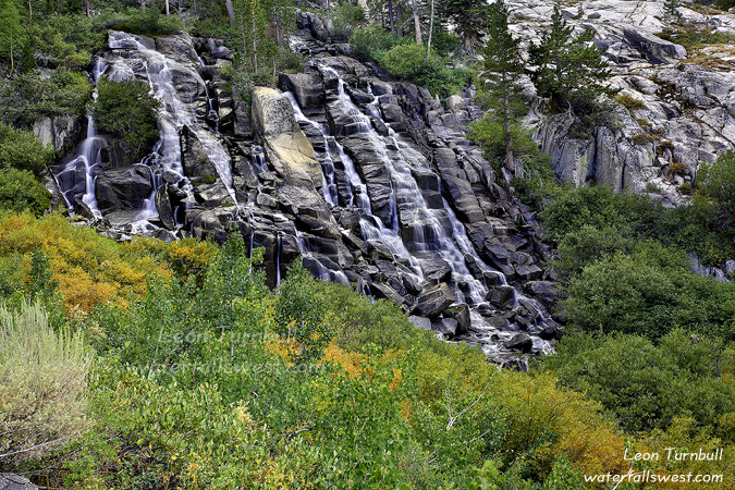
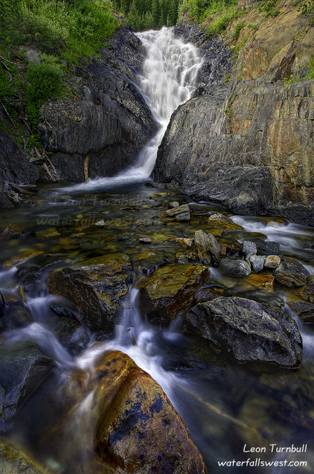
This is Upper Horse Creek Falls, 82 ft. high. It is a very pretty waterfall. I was a bit shocked to see all the yellow bushes around the base of the falls. You might think this shot was taken in October. But this is the end of August, and they are changing color already? The Aspens are still very green, but I’m not sure why the other bushes are yellow yet (I know they are not yellow all year). Anyway, I think this might be a very pretty scenic waterfall to shoot when the Aspens are changing as well.

After shooting Lundy Canyon in the morning, I drove into Lee Vining, had lunch, and then took a nap in the afternoon. My original plan was to shoot sunset at Mono Lake, sleep overnight in my vehicle somewhere, then get up in the morning to do another hike. However … the entire area was covered in heavy stormy clouds, it was starting to rain, and it sure did not look like there would be much of a sunset at Mono Lake. I thought to myself, well what should I do? I could stick around and hope the skies clear for sunset. It was a possibility. But there was another option. I could just skip Mono Lake, do my other hike in the afternoon, and drive home that same night. I was very tired from my morning hike in Lundy Canyon, and was not sure I could do another high elevation 4 mile hike. But the nap refreshed me and gave me energy back. Plus, I didn’t really want to stay the night in Lee Vining anyway. I would be kicking myself if there ended up being a spectacular sunset at Mono Lake, but I decided on Plan B. (as it turned out, the clouds seemed to get worse by sunset, and I don’t think there was much of a sunset at Mono Lake that evening – whew).

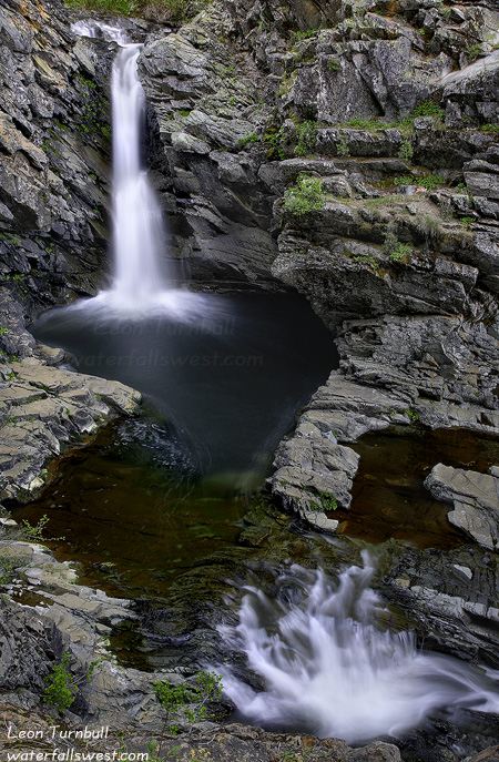
So I drove up to Twin Lakes at Bridgeport and started hiking up to Horse Creek Falls. The hike gains 1100 ft. of elevation in 2 miles, but the grade was very gentle and easy going. I felt very good and had no troubles with the hike. I noticed that there are tons of deer around Twin Lakes. In fact, I think I saw more deer on this day, then I have in the past 3 years total. I think the campers feed them (which is not very smart), as I saw one person hand feeding one deer, and another one I saw on the trail walked right up to me (looking for a handout, I guess). It was quite tame but I had no handout for her, so continued on past. There are two waterfalls on Horse Creek. The first one is a big one, and I think most people do not even realize it is here, or how big it is anyway. The trail comes to the bottom of the cascade, then switches back well away from the creek, and comes back to it at the top of the waterfall. The total height of the waterfall is about 360 feet. But from the trail, you can only see the bottom part of it, and when the creek flow is low, it does not look very impressive. In the spring it would look a lot more interesting. On my way back down, I hiked right alongside of it from the top to the bottom (off the main trail), and I found some good spots to photograph it. It is definitely a fabulous cascade.

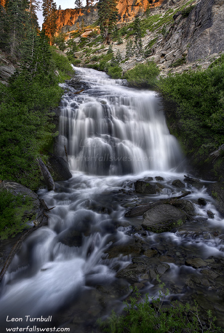
Upper Horse Creek Falls is 82 ft. high, and is a much prettier waterfall and the trail goes right beside it (and thus, I think more people stop here to look at this one). This one looks nicer when the flow is lower as well, as it comes down in many small rivulets. It is a beautiful hike, I think I’ll definitely be back here someday.

No Comments

Lundy Canyon

This past weekend I made a very quick and very long trip over to the Eastern Sierra. The weather had significantly cooled, and storms were on the forecast for the Sierras. It was my kind of day, and I was ready for some hiking. Especially since it would likely be my last hike for the summer, with minor surgery scheduled for the next week, and recovery time needed afterwards.

So with absolutely zero sleep (I can never sleep the night before I am trying to get up early), I got up at 2AM and headed out on the long drive over to Lee Vining. While driving over Monitor Pass, I was greeted by a pack of coyotes along the road. I do not think I have ever seen a pack of coyotes before. I always see them only one at a time. They were rather curious, and watched me from the side of the road as I drove slowly by them. So this was definitely kinda neat, and I took it as a good omen for the day (whether it was or not, is another question). There were about 7 or 8 of them, and they all seemed to be rather small. (unlike the huge one my wife and I saw once on Ice House Road – that one was as big as a wolf). Perhaps these ones were just pups, but if so, I didn’t see mom or dad.

My plan for the day was variable. If it looked like it would be a spectacular sunrise, I was going to Mono Lake. I arrived in the area well before sunrise, and although there were some clouds over Mono Lake, it definitely was not going to be spectacular. So I headed up Lee Vining Creek to the powerhouse at the end of the road. There is supposed to be a trail from here going up the canyon to a waterfall. Well, I could find no such trail. I looked and looked, and wasted a lot of time trying to find it. The powerhouse area is closed to the public, and I could not find a way around it. Well as it turned out, the creek was not flowing very well above the powerhouse anyway, so the waterfall would be just trickling. My next destination of the day was Lundy Canyon.

It was of course well after sunrise by the time I got to Lundy Canyon. But the light was off and on all morning. There were plenty of clouds and they were moving in and out from in front of the sun, so although the light was bad at times, I just had to wait a few minutes and it would be cloudy again. I was hoping it would be a lot more overcast, but this was all right. I took a lot of photos in Lundy Canyon and this one was my favourite of the day. There are 6 significant waterfalls along Lundy Canyon Creek (including a 500+ footer). This one (30 ft.) is the smallest, but it is also arguably the prettiest. The 500 footer was pretty spectacular as well. This was the main reason I wanted to go back into Lundy Canyon as I had not been to the big waterfall before, but it was a bit difficult to photograph (it is posted on my main website). Anyway, it was quite a tough hike up Lundy Canyon, and I was quite tired afterwards (especially from the high elevation), but it was certainly a fabulous morning in the Eastern Sierra.

2 Comments

The East Fork of the North Fork of the North Fork of the What?

Digging into the archives. This shot is from a couple months ago. I did have a very nice day in the Eastern Sierra yesterday, and I will be posting shots from there soon.

I went searching for a new waterfall up by Emigrant Gap on the East Fork of the North Fork of the North Fork of the American River. The what? That is actually the official name of this river. But perhaps we shall just call it the East Fork. It was flowing pretty good when I was here. There is no official trail leading down the river, but I did find a very old, very overgrown, very faint resemblance of a trail. I followed it with great difficulty downstream. The problem was, it was taking much too long. It is only a mile to where I think there is a waterfall on this river, but after an hour of hiking, I still hadn’t gone half way. There is no way I could continue down and be back before dark. Thus I decided to turn around early, and try again another day. I think that I could have continued further and hopefully reached the falls, though I’m not sure I would have even been able to even get a view of the waterfall from what I have read about it. Nonetheless, I will have to try another day.

I returned back to the car, then went back down to the easier to reach North Fork Falls. This one is on the North Fork of the North Fork of the American River. That name is a bit (albeit just slightly) easier name to digest. The waterfall is 27 ft. high, but it is more difficult to view than what I remembered as well. You need to cross the river near the bottom of the falls. That was easy enough, though I did need to get my feet wet to do it. The river’s flow was significantly reduced, I had hoped to see the falls with much greater flow. On the other side, there are some steep cliffs that you need to scramble up, then across, and back down to the waterfall. That was more difficult than what I remembered, and I was not wearing my hiking boots, making it slightly more treacherous. I took this higher perspective photo this time of the waterfall, instead of going right down to the bottom. I do like this higher perspective, though I wish I had gone down to the bottom as well.

2 Comments

More Kings Creek Cascades

Here is one more from the bottom of Kings Creek Cascades, as the sun is starting to light up the canyon walls at top.

No Comments

Silver Fork

I’ve been wondering for a few years now about the Silver Fork American River. Specifically, wondering if there are any waterfalls on it. I had not heard of any. But surely, I thought, there *must* be a waterfall on this river. Not a big one, I knew, but there must be a small one, a decent one, somewhere on this river.

I studied the topo maps. Studied them some more. I came up with a possible location. It even looked like there was a trail leading right to it. Sweet.

Well fast forward to a Friday evening in late July. I was in a certain mood. An exploring mood. But not for any difficult exploring. I wanted to get out of the house, get up in the mountains, away from the heat of the city. But I didn’t want a difficult hike, just an easy one, but not too easy. Well, where could I possibly go for that? Then a light bulb clicked. How about the Silver Fork? Seemed like a great idea. That river would be still flowing decent. It is not too far from my house, and the hike should not be too difficult. Perfect. And off I went.

I drove up the Silver Fork Road at Kyburz. I found that it was paved the whole way. That was sure nice. I didn’t want to have to wash my vehicle again so soon. I arrived at the trailhead, and I was surprised to find there was a campsite here. I didn’t know there was one here, and I didn’t know where the trailhead was, so I wandered through the campsite in search of the trail. Eventually I found it, and it would have been easier to find if I went the correct way, but oh well.

Once on the trail, things were easy. The trail leads up to where Caples Creek flows into the Silver Fork, then crosses Caples Creek on a bridge, and leads back to the Silver Fork. Both Caples Creek and the Silver Fork had pretty good flow. I arrived at the spot where I thought there would be a waterfall, and yay, lo and behold, there was one.

But I was quite early, the sun was still shining down into the canyon, and I felt like doing more hiking. So I continued on up the trail for another couple miles. The trail was mostly flat the entire distance, so it was a good hike and not too difficult. Just what the doctor ordered. I realized that I could have hiked all the way to Silver Lake. It would not have been all that far to the lake, but it was a bit far for me on this day, so I turned around well before getting to the lake. On the way back, I heard a totally obscene and outrageous noise coming up the trail interrupting my beautiful, pleasant hike. It was someone on a motorcycle coming towards me. I got out of the way, but this really irritated me because motor vehicles are not allowed on this trail. There are plenty of places where people can ride their motorcycles and not chew up nice hiking trails. Argh.

Anyway, I arrived back at the waterfall. As you can see from this photo, it does not look like much of a waterfall. I measured it to be 23 feet high. The problem with this waterfall is that it needs a lot of water flowing in the river to make it look good.  There are so many boulders in the river, when the flow is lower in the summer, it just doesn’t look so good. But in the spring, when the flow is high, I think this waterfall would be rockin. I definitely plan to be back here next spring. Though I won’t be able to stand in the middle of the river to take photos in the spring, so that might make things more interesting.

2 Comments