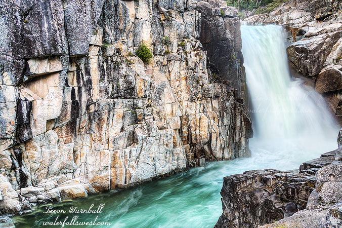
DAY 1. A RIVER RUNS THROUGH IT

If it looks like a river, and if it acts like a river, and if it talks like a river, then it must be a river. But in this case, it is not a river. Hiking into West Cherry Creek Canyon has been at the top of my list for awhile, and this year it was a priority to make it there. I brought my son Jadon along for this journey. It was going to be epic, I just knew it would be, and it was.

We arrived at the trailhead and started hiking around 8AM. The first day would be a 12 mile hike, but elevation gain was minimal, and we had all day to do the hike, so overall it was fairly easy. However, Jadon really struggled, especially the last part of the hike. He was very tired, his feet hurt, his shoulders hurt from the pack.

The weight of his pack was only about 20 pounds, compared to the 40 I was carrying. I carried a lot of the extra weight for the two of us (food, etc.). I would have given him more weight, but he does not get much exercise normally, so I figured he would have a hard time as it was, and so I guess I was trying to be nice. I did not mind. I am glad he came with me.

It took us about 8 hours to get to West Cherry Creek Canyon and to our campsite. As we descended into the canyon, we got our first view of the upper falls. West Cherry Creek was roaring! The creek did not look crossable. Indeed, it was not a creek, it was a river. I did not have plans to cross the creek, I just wanted to camp on this side of the creek, but I was not entirely sure if we would need to cross it to view either of the two big waterfalls. West Cherry Creek Canyon is incredibly beautiful. The scenery is among the best I have ever seen in my life. I fell in love with this canyon. I did not want to leave. Ever. The canyon is flanked by two tremendous waterfalls, both of which are well over 100 ft. high. In between, the canyon is guarded by towering and majestic granite cliff walls with no exit point save the one we entered down into. The beautiful river runs through the middle of the canyon. It is absolutely stunning.

I do not think Jadon had the same emotional experience that I did. In fact, I know he did not. I tried to get him to see it. See the beautiful green pool in the river, it looks so inviting to swim, doesn’t it Jadon. Look at the beautiful sunset light on the granite cliff, Jadon. See the moon setting over the end of the valley, Jadon. See these magnificent waterfalls, Jadon. He just seemed to be more focused on the difficulty of the hiking. Well, I really tried. Hopefully, something sunk in. I really enjoyed experiencing this with my son, and I want him to come with me on more trips in the future.

For the first day, we hiked down the valley to the lower waterfall. There was a pretty good trail through the canyon, though it was difficult to follow at times. I was surprised this section was so easy going and there was a good path. Somewhere along the way, my tripod fell out of my pack. As we neared the end, I noticed it was gone. Jadon had been behind me and apparently noticed it, and walked right by it. Oh, I saw a tripod and I was going to say something, but I did not think it was yours. What????? Whose else would it be????? Well, I had to go back and fetch it. It just gave him more time to rest.

We found a terrific campsite above the falls, setup camp, had dinner, then went down to the waterfall. This was the very tricky part. Getting down to the bottom of the waterfall was just slightly crazy. The waterfall goes over a steep granite ledge. The one and only way down is to walk down the granite rock right beside the waterfall. If the rock is wet at all, forget it. You would die. That is no exaggeration. However, the rock was completely dry. It was a bit nerve wracking, but actually quite safe. We had to be careful of course, and we scooted down on our butts on the steepest parts. Once down, we had to wait about an hour for the sun to go down before I could take photos. I explored the canyon, while Jadon napped on the rocks. It was a glorious evening.

It was supposed to be down to freezing the first night, but it did not seem to get quite that cold, though it was definitely under 40 degrees. We were prepared and we were warm enough in our sleeping bags. The only problem is that my brand new inflatable pillow has a leak. I’m going to have to return it. Argh.

2 Comments

LOIS

On Memorial Day weekend, I went up into the Desolation Wilderness for a quick 1 night backpacking trip to Lake Lois, a spot I’ve wanted to see for quite a while now. I’m glad I did, it was so incredibly beautiful.

I was certain there would be snow up there, so I brought my snowshoes along. I was not sure if I would need them, but I wanted to make sure that I would get to my destination successfully. The worst thing would be if I did not bring them and then have to turn back because there was too much snow to get through.

I was also concerned that the waterfalls might not be flowing at all because there was still too much snow. Surely by now, the snow would be melting and the creeks would flowing strong. It was a 50-50 chance, I estimated.

Well guess what? There was too much snow!

On the south side of the mountains, I climbed up about 1500 ft. to the top of Rockbound Pass. There was very little snow on the south side, so I was carrying the shoes the entire way. Immediately, as I got to the top of the pass at 8550 ft. elevation and started to head down on the north side, there was complete snow coverage. The snow depth was at least 4 to 5 feet, from the top of the pass all the way to Lake Lois. This was much more snow than anticipated.

Thus, I put on my snowshoes at the top of the pass and wore them the entire way from there to Lake Lois. But did I really need them? Did I really need to carry an extra 4.5 pounds all the way up to the top of the pass? (p.s. I think my snowshoes gained a pound since my last hike). As it was Memorial Day weekend, I saw quite a few other backpackers going up over Rockbound Pass. None of them had snowshoes. I was the only one. So either they were all fools, and I was the only smart one, or else I was the fool and they were all smart. So which was it? Maybe it was both and both. The snow was soft, but no one was postholing through the snow. This was the big reason I brought them along. The snow this spring has been much softer than normal, and I have seen firsthand and heard from others experiencing a lot of postholing. However, here in Desolation, it was definitely possible to walk on the snow without snowshoes. Nonetheless, the snowshoes definitely helped and made the hike much easier. All in all, I am glad I brought them. It was easier and safer walking on the soft snow with the snowshoes.

As I headed over to Lake Lois, I followed some other tracks in the snow that seemed fairly recent. It seemed as though I would have some company at Lois. Then the tracks went off in the wrong direction, down the canyon, away from Lois. There was nothing down that way. Maybe these people got lost, and I would be hearing some horror story about them in the near future. I headed off to Lois in the proper direction. As I approached the lake, however, the tracks re-appeared. I guess they managed to find the way to Lois after all.

Lake Lois was completely iced over. I could see that the inlet waterfall was still snow covered and was not flowing. Bummer! I suppose I should have known it would be like this, but I was hoping I would find it differently. Nonetheless, the lake was incredibly beautiful.

There were very few dry places to camp. Everything was in the snow. Everything that did not have snow, was all rocky. The other backpackers had snatched the one and only good place to camp, and had their tent in the only flat spot that was not rocky. I did not want to have to setup my tent in the snow. Would I have any choice? I continued to the outlet stream. I found this stream flowing quite strong. It would be tricky to cross and keep my feet dry at the same time, and I did not want to cross if I did not need to.

On the other side, everything still looked very rocky. Far off, I could see another couple backpackers, and it looked as though they were packing up and headed this way. I decided to wait for them and ask if they had a decent spot over there or not. As it turned out, they did have a very good spot on the other side. I crossed the stream where they did, which was on a flimsy looking snow bridge over the creek. Would it hold up? I’m sure I weighed more than they did, especially with my 4.5 pound snowshoes.

Well I did not fall through the snow, and I made my way over to the camp. There was really only one spot, but it was perfect, with a nice flat area to setup my tent, probably better than the spot where the other backpackers were. Fantastic. I got everything set up, had my lunch and relaxed for the afternoon. It was nice and warm when the sun was out, but when the clouds covered the sun, it was quite chilly.

In the late afternoon, I wanted to check out the lower outlet stream. I put on my snowshoes and wandered downstream. It was very easy going and the descent was gentle. There was one steep part, for which I took off my snowshoes to make sure I had good traction going down. After this, the snow disappeared, and it became much easier to hike down the mountain.

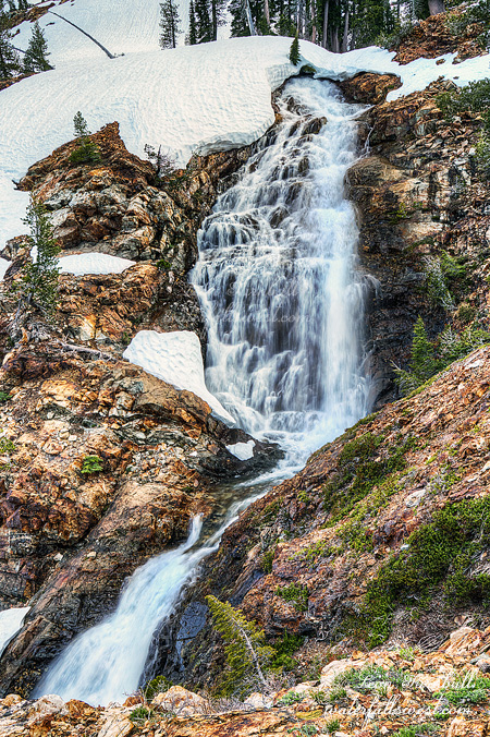
The creek gave up its gentle descent and made a big drop. I found two fantastic waterfalls, a 50 ft. cascade, followed by a 60 ft. drop. It was easy to get down to see both of these, and they were not snow covered! I was a very happy camper. This made the long hike to Lake Lois all worthwhile.

I got back to camp, and got ready for bed. I had the entire area on this side of the creek to myself, no one else around. It would be around 38 degrees or so this night. I had a new 17 degree sleeping bag so I was not cold at all, but I could not sleep very well. I just could not get comfortable on my sleeping pad. I do not know why. It was a restless night.

In the morning, I got up fairly early, but not too early. I packed up my gear and took my time eating breakfast before heading out. The snow was much harder in the morning and in fact, it was easier hiking in my boots and so I carried my snowshoes all the way back, not using them at all.

Back up on top of the pass fairly quickly, it was a long descent from there back to the car. No more snow. I saw some marmots, 5 or 6 of them, and they let me get close enough to them to take photos and video. Cute fur-balls. I was hot and tired when I got back to the car, but it was sure a fantastic trip to Lake Lois in Desolation Wilderness.

No Comments

IMPASSE

Here is one more from Palisade Falls, my big backpacking trip down into the North Fork American River canyon a couple weeks ago.

This last weekend I tried to get into Wildcat Canyon Falls again. The last time I was there was in 2007, 11 years ago. I did not make it this time. I got almost all the way down there, I could see one of the waterfalls off in the distance, but then I hit a wall of brush. For the last half mile or more, there was a mound of thick brush, at least 6 feet tall, and completely impassable. Eleven years ago, there was no brush at all. Unbelievable and incredible and so disappointing.

This is now the fifth trail I have tried into the North Fork American River in the last couple years, all of which are now impassable. American River Trail: impassable, Beacroft Trail: impassable, Mumford Bar Trail: almost impassable, Big Granite Trail: impassable, and Wildcat Canyon Trail: impassable. These used to be all excellent trails, they are my favorite trails in the world, and now you cannot hike them at all. Tahoe National Forest has not done anything to maintain these trails whatsoever, and now you cannot even hike them. What a horrible shame. The only trails that are still good are the Palisade Trail, and Sailor Flat Trail (I think – but I have not hiked this one recently). I could very well be wrong, but I do not really sense such a huge issue for trails in other National Forests, but only in Tahoe National Forest.

I am at a loss what to do; however, I’ve been thinking about it. I thought maybe I should go in and clear them by myself, but that would be impossible. One person hacking down a wall of brush 6 feet high for a half mile? That would be senseless. One thing I am doing is sending a letter to Tahoe National Forest about it, and I urge you all to do the same thing. These trails need to be restored. I am even going to volunteer to help them do it. I am waiting for a response from them. We will see what happens, but I am sure the excuse will be no funds or some such thing. Sigh.

2 Comments

DANGER, WILL ROBINSON!

So have you watched the new Netflix series Lost In Space? I have recently just finished watching season one. I love it! I think it is better than Stranger Things (is that blasphemy?). I never watched the original series so I have no comparison, but I really like this new show. The famous saying in the series is when the robot says “danger, Will Robinson”. So what does that have to do with this waterfall???

Well … first off, this waterfall is Little Robinsons Valley Falls, for which the trail starts at Robinsons Flat. Robinson, get it? I drove up here on Saturday afternoon, thinking that I would not be able to drive all the way up to Robinsons Flat. The Tahoe NF office was saying I could only drive to Ford Point. I thought that would be highly unlikely, they are always completely inaccurate at Tahoe National Forest; I was expecting to drive to Tadpole and walk from there. There was no snow at Tadpole, so I kept on driving. On Canada Hill, there was one big snow patch, for which I was very leery of driving through. Indeed, I was not going to attempt it. However, I saw a small truck without 4 wheel drive coming down the hill. He had no problems. Heck, if he can make it, then surely so can I. I have 4 wheel drive! It was not very difficult to drive through that patch, and after that, the road was “mostly” clear all the way to Robinsons Flat. Perfect! This would save me 3 miles (one way) of hiking. There was quite a bit of snow at Robinsons Flat, and I was hiking in it to start with, but I was not sinking in (much), so I did not need to use my snowshoes. Even though there were other cars that had driven up here, mine were the only foot tracks going down the trail. Except for the bears and coyotes, that is.

I was not planning to go to Little Robinsons Valley Falls. I wanted to continue hiking past it, down the canyon. For some reason, I thought there would not be much elevation loss on this hike, only a couple hundred feet or so. I did not check my maps closely enough. It was about 1000 ft. elevation loss. Not only that, the hike was much longer than anticipated because apparently the trail has been re-routed to avoid some difficult sections. Oh well, I was not concerned about all that. I had lots of time. It was an awesome day, and an awesome hike.

When I got down to where the waterfall should be, however, I found no waterfall. Actually, there was one but it was just a small one. The terrain was very cliffy. The rocks were crumbly and loose, with steep dropoffs. I went down quite a way, but I could not get all the way down to creek level. Danger, Will Robinson! It was not worth the risk for such a small waterfall, so I decided to turn back.

I ate my food, then hiked back up the trail. When I got back to the turnoff for Little Robinsons Valley Falls, I hummed and hawed.  Should I go down to it or not? I had 30 minutes until dark. It was just enough time (barely) to hike down to the falls and back. I decided to go down. I took a quick shot of the upper tier, but there was no time to go to the lower tier. I got back to the car just as it was getting dark. It was a fantastic evening in Little Robinsons Valley.


No Comments

PALISADE CREEK FALLS

This is the middle tier of Palisade Creek Falls. It is a massive 3 tiered waterfall. It is magnificent. Only the middle tier is easily accessible and photographable, however. I wanted to photograph the other two tiers, but I just could not find any good viewpoints for either of them.

No Comments