DAY 2. GOT GAS?

Got gas? No sir. Negatory. Nopity nope.

In this case that is actually a bad thing. After I made my dinner on the first day, I realized my gas canister was now empty. Crap! I was so careful about checking everything on my backpacking trip, but I did not check my gas canister. I was certain I had enough for another trip. Stupid stupid stupid. I had to eat all my snack food for breakfast the next morning, and now I did not have enough food to stay somewhere a second night, as I had initially wanted to. I had two lunches (for 2 days), and no breakfasts or dinners to eat. So I packed up my gear and hiked all the way back. 11 miles. All the way back to Loon Lake. In the heat. I did not get back to the car until after noon, and I was dead tired. Did I say it was hot? Bummer, but I did have a totally epic first day on the trip. I found two, yes two, incredibly spectacular waterfalls, and a third one as well that was not too shabby either.

When I first planned the hike to Horseshoe Lake Falls, I did not think I would go up to McConnell Peak Falls. I did not even consider it at first. However, when I studied the route on Google Earth, I saw that it did not look too difficult to climb up to the top of Horseshoe Lake Falls, and from there it is a short distance to McConnell Peak Falls. This new hike was now on the agenda. Totally on the agenda. These two waterfalls in the Desolation Wilderness have been on my radar for a few years now, but before now they both just seemed too remote to reach.

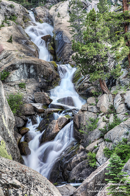
It was a bit steep and sketchy in a couple places but overall not too hard to climb to the top of the first waterfall. From there I got on an actual trail, and continued up to Horseshoe Lake. The trail is not much of a trail, but it is a trail. Sort of. Sort of not. In other words it is a bit faded and hard to follow. At Horseshoe Lake, I got my first glimpse of McConnell Peak Falls. My thought was: yeah it looks like it is ok. You are still quite a long distance away at Horseshoe Lake. Initially, I thought I would just take a photograph of it from Horseshoe Lake and call it a day. However, it was still early, the lake was still in the sun, and would be for at least 3 more hours, and oh yeah, there were mosquitoes at the lake. I did not want to wait around 3 hours with the skeeters. Plus, I could not see any good compositions of the waterfall from the lake anyway. The trail was pretty good from the lake, so I continued onwards. It meanders through the forest before it comes out right at the base of the waterfall. When I first saw it up close, I exclaimed out loud something to the effect: holy crap is that ever awesome! This is most certainly one of the most spectacular waterfalls in the Northern Sierra, and without a doubt it is the best waterfall I have seen so far this year. About 470 ft. high, and flowing very strong. In the Desolation Wilderness, it is second only to Horsetail Falls (590 ft.). There was still plenty of snow melting from McConnell Peak in late July. It is crazy awesome that you can get right to the base of this giant waterfall and look up to see the entire thing crashing down the cliff. Wow wow wow! It is also crazy that I have never seen any photos of this massive waterfall before. The trail goes right along the bottom of it, but this area is so remote, I do not think it ever gets very much traffic, even in the summer after the snow is melted and the waterfall is reduced to a trickle. Seeing it now, after a great snow year, and flowing so strong in the middle of summer, is something that very few people have ever seen. After seeing these two incredible waterfalls, I didn’t feel so bad about having to hike home a day early. It was an incredible trip into the remote Desolation Wilderness.


2 Comments

DAY 1. GOT MOSQUITOES?

Got mosquitoes? No sir. Negatory. Nopity nope.

I have heard that the mosquitoes have been horrendously epic this year in certain places such as the Eastern Sierra and Yosemite high country. That would make sense considering the big winter we had. I have avoided going to those places this summer even though I did want to go. I hate mosquitoes. Perhaps I will go later. Yet I also heard they are not bad at all in other places of the Sierra, even in some places that are normally horrible such as Wrights Lake and the Desolation Wilderness. I like hearing stuff like that. It’s off to the Desolation Wilderness for me.

I did not really want to go backpacking again this summer (I still want to go more in the Fall). It is 100 degrees in the valley and pretty hot in the mountains also. However, my wife and kids are gone for the week and I was playing a bachelor with nothing else to do. I suppose I could do a couple day hikes but I could not think of anything good so backpacking it is. I figured if I could do all or most of my hiking in the morning it would not be too bad. Hmph. Yeah, right.

I left early for Loon Lake. I heard there were not any mosquitoes here last week so maybe it would be ok at the place where I was planning to go from there. There weren’t any when I arrived at the trailhead about sunrise.

What about my injury? My arm and leg have had a lot of pain the last 3 to 4 weeks. My arm is now completely healed and my leg is getting there but not quite. This last week was the first time I’ve been back to the gym. I realized it was the machine at the gym I’ve been using that caused the injury. If you keep doing the same thing over and over and more and more of the same thing then you can get hurt. Carpal Tunnel is a good example. When I go to the gym from now on I need to be careful to mix it up a lot more. Anyhow, the leg has not been hurting when I have gone hiking, so this trip should be ok.

This would be an 11 mile hike one way with minimal elevation gain and mostly all of it on a well maintained trail. It should be easy as pie. Well we all know that when the Madman says that it usually means it is not going to be anything of the sort. However, surprise surprise, this time it actually was easy. But when I hit that sun at around 9 or 10am, it was definitely hot already. Good thing I started early. I would not want to be out hiking in the afternoon for sure.

I saw one weird slug like snake thing on the trail. Is it a giant slug or a strange snake? A snake obviously, but I did not know what kind of snake it was. I poked it (gently of course!), it only moved a microcosm. Not a rattlesnake. I looked it up later, and I believe it is the northern Rubber Boa. I don’t think I have seen one of these before.

Much of the trail was very rocky. I hate hiking on trails like this. It is very hard on your feet and you get blisters galore (and I got blisters galore). You have to pay attention to where you are walking so you don’t twist an ankle, and generally just try to walk on the flattest rocks. As I was walking along, keeping my eye to the ground, I heard and glimpsed out of the corner of my eye a large animal coming out of the bushes towards me. I realized it was going to attack me, whatever it was. Was it a bear? Was it a mountain lion? Was it a Sasquatch? No, it was a big dog and it came at me barking loudly. It scared the living crap out of me. I really thought it was going to attack. I fell back and tripped, landing on my butt on the rocks. Ouch. Where are the owners of this thing? I finally saw them coming up the trail and they called the dog away. Damn. I really don’t mind dogs on the trails (in fact, it’s my number one pet peeve when dogs are not allowed) and I don’t mind them being off leash either, but not if they are going to attack people and you cannot control your animal. Keep it on the leash people! I wonder how many other people that dog scared this weekend.

After 10 or so miles of hiking, I came to the Rubicon River crossing. The river was flowing hecka strong, most hikers continuing from here would need to cross the river. I do not know how anyone could cross here, but I have read of hardcore hikers making dangerous crossings this year. Not for me, thank you. This is where my trail ended. I would not need to cross any rivers, but I would need to go cross country from here. I could see the waterfall in the distance. My final destination was not far.

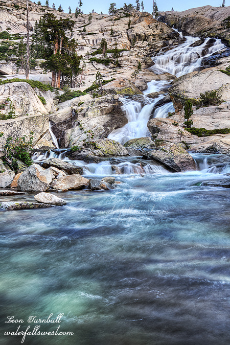
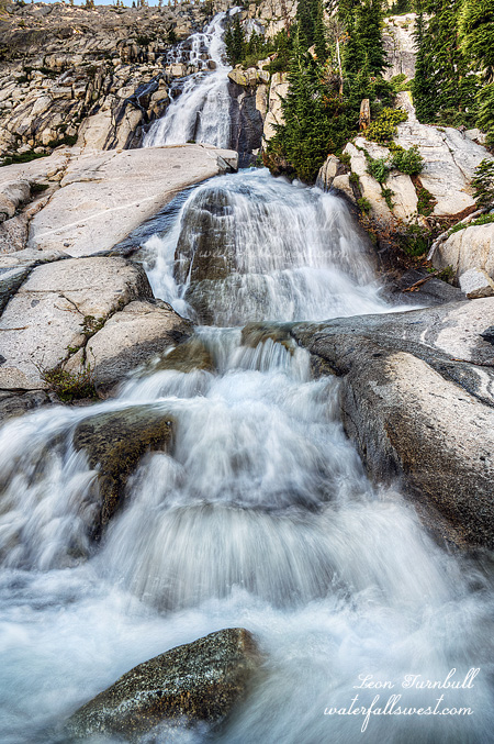
I arrived at Horseshoe Lake Falls where I would camp. The waterfall was spectacular! It is about 280 ft. high and still flowing strong at the end of July. Incredible beauty, and I would be camping right beside it. Finding the perfect and epic campsite in the remote wilderness is an art form. There was a very small spot for my tent near the creek with a great view of the falls. It had a big tree that would keep me in shade all day, and a nice little breeze. Perfecto. There were a couple other slightly bigger spots but they had no shade and there was more brush which I thought might bring out the skeeters in the evening. I set up my camp, ate lunch, and relaxed all afternoon, listening to my music, and watching thunderstorm clouds develop in the distance. All afternoon, they were really trying to come towards me from two different directions. They would start to come closer, then they would move off in the other direction. It would continue like this all afternoon. I thought I kept hearing thunder in the distance, but it was hard to hear anything over the roar of the waterfall. In the end, however, God kept the clouds and rain away from my location. Thank you for that, Lord.

I took my photos of the waterfall in the evening. There were many good view points and I took many photos. However, I think a better view would have been on the other side of the creek. I tried to cross it, but I balked. The flow was just a bit too strong and deep. Never mind the Rubicon River, I could not even cross this little creek. Perhaps if I had my proper water shoes I could have done it (not sure), but I only had my water socks which have zero traction. The pull in the creek was strong, and the rocks slippery. If I had slipped, I would have been gone over a small waterfall. It was definitely not worth the risk. I still had a great view from the bottom of the falls, standing in the middle of the creek (where the flow was minimal). It was an epic day of backpacking, and it was not over yet…


2 Comments

THE BLUES

I heard from a friend that the road to Blue Lakes was finally open as of this past week. I’ve always wanted to go there and never have. Until now.

I woke up while it was still dark and began packing up my tent and other belongings. As I mentioned in the last post, I forgot my headlamp. It is a bit tricky holding onto your iPhone light with one hand, while taking down and folding up your tent with the other hand. It was a one-handed tent folding extravaganza. Well, I managed to do it fairly quickly, and did not wake up any of the neighbor campers in the process. I drove down the hill and over to the Blue Lakes.

This was supposed to be a short and very easy two mile hike (one way). Of course it never works out that way for the Waterfall Madman, does it? At the first (lower) Blue Lake, I found that the road was blocked/closed. It was only blocked with a couple measly pylons that I could have easily driven around, but there was a closed sign there, and I was unsure why the road would be closed. It should be open but maybe there was a good reason it was blocked, such as snow on the road, giant mud pit ahead, road damage, etc. etc. I have never been here before, I did not know the ropes of the land so to speak, so I parked my car and walked. This would add 2.5 miles (one way) to my hike.

That is no big deal. However … now I had a sun issue. I had to be at the waterfall before the sun got onto it. By my calculations, it was now touch and go and I did not think I would make it in time. There was only one thing to do: run. On the downhill parts of the hike of course, not the uphill parts. I do not like to do this on my hikes, but I figured I had no choice. Much better to do this than to arrive at the waterfall too late and not be able to take a decent photo. So I ran and ran and ran, trying to make up just a little bit of time on the hike. Fifteen minutes or so was all I needed.

By the way, the Blue Lakes are incredibly beautiful – if I did not say so yet. The snow capped mountains in the background, and the blue colored lakes (yes, they are blue colored). Wow. A bald eagle soaring through the sky (yes indeed!). There were mosquitoes as well, the only negative thing I found there. There was snow on the trail as well, starting at 8200 ft. This created a conundrum. The trail follows a seasonal creek for awhile with steep banks. There were big unstable snow bridges on steep snowy slopes. I climbed high above the creek to get around this section. The route got much better after that, but it was very difficult to follow the trail proper with the snow cover. All of this slowed me down immensely. Could I still make it in time?

I arrived at the creek crossing. It was only a half mile from here to the falls, but I was late now. I could not jump or rock hop across this creek. I would be getting my feet wet for sure. However, to change out of my boots and into my water shoes would take precious time which I did not have. I walked straight across the creek in my boots. Two quick steps into the water. My feet were now wet but I did not care. I ran down the trail.

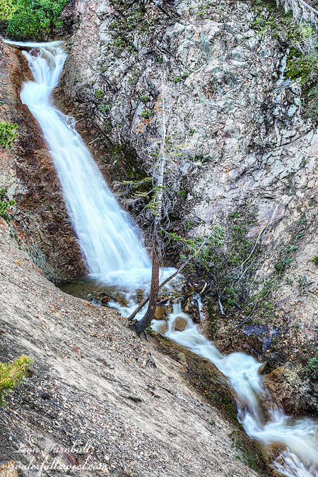
And promptly went right past the waterfall. You cannot see the falls from the trail, and it is difficult to know exactly where it is or where to go. I came down to the lower cascade, which is not terribly interesting, but I took a couple quick photos. Now I had to climb back up the hill to get to the main waterfall. I figured by now I would be too late, and the sun would be on the falls. I hoped, I prayed, I would not be too late. Thankfully, it was still in shade. Actually, I still had a lot of time to take my photos. Whew.

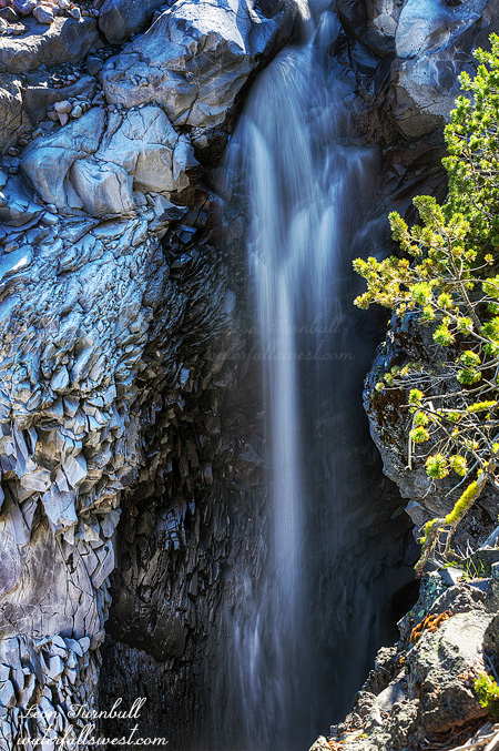
It is incredibly steep here. In order to see the waterfall you need to climb down the crumbly, near vertical slope. I did not have my rope. That was a mistake. This was dangerous stuff but I had to get a photo of this waterfall. Was it foolish to go down here with no rope? It was not ideal, but no, I was careful, very careful. I took some photos. Now I could relax.

On the way back, when I came back to the creek crossing, I saw, I glimpsed, a large brown animal running away as I approached the creek. What was that? Was that a bear? Was that a cougar? Or was that a deer? I did not see it clearly, and it could have been a cougar, but I think it must have been a deer. I hoped it was a deer. At least it was running the other direction.

I took my time hiking back to the lakes. No more running. Let’s enjoy the rest of this hike, shall we? When I got back to the lakes, I found many cars had now driven up the road. I guessed the road was now open officially, but in fact, I learned that they had driven right past those pylons that were blocking the road. I could have done this, had I known it was ok to do so. Oh well, it was a good hike. It was a beautiful hike.

No Comments

MYSTERIES

I have never been to the waterfalls on Hwy 4, Ebbetts Pass before. This seemed like a good weekend to go up there. In fact, I have never driven Hwy 4 from the Markleeville side. I drove up to the summit from the Arnold side once, but that is it. I have to say for such a major highway, the road is extremely narrow going up to the summit on the Markleeville side. You sure hope a big truck won’t be coming down as you are driving up.

Anyway, my idea was to drive up there after work on Friday, and camp in my tent at the campsite up near the waterfalls. Normally I would take the Gator (as we call it affectionately – the SUV), and sleep in the vehicle, but my wife had the SUV this weekend, so I drove the little car. No possible way to sleep in that thing so I brought my tent instead. I arrived at the campsite, found quite a few open spaces, selected one of them, paid my fee, set up my tent, then took off to find some waterfalls before dark.

I have heard this waterfall called Silver Creek Falls and Upper Cascade Falls. I never understood the Upper Cascade name. It makes no sense. Does this mean there is a lower Cascade Falls as well? I also did not know if these were two separate waterfalls or they were one and the same. Well I think I figured out the mystery now that I have finally been there.

There is a sign along the road near the top of the falls that says Upper Cascade Creek. So that explains the name. Actually, there are three creeks that come together here, and two more drop in below the falls (and a few more below that). One of the other creeks is Silver Creek. In fact, after they all come together Silver Creek rules the day so that technically makes the official name of this waterfall Silver Creek Falls. But if you want to call it Upper Cascade Falls, then go right ahead.

Silver Creek Falls is certainly a beautiful cascade, 64 ft. high. I walked down on the granite rocks below the highway. You come to a fabulous view of the falls from on top of the rocks. The dropoffs here are intense. I got as close to the edge as I dared, I was not wanting to slip off the edge on that slick granite.

I enjoyed the view, made it to a couple other waterfalls in the area as well, then arrived back at the campsite at dark. This is when I realized I did not have my headlamp. Doh! Where was it? Did it fall out of my pack? Or did I leave it in the other vehicle? (the latter, as it turned out). It is supposed to always be in my hiking backpack so I was a bit stressed about not having a light. At least I had my iPhone light. As long as my phone battery did not die, I would be all good for one night.

Also, as I locked the car for the night, I noticed small red lights on the doors. I have never noticed this before. I don’t usually drive this car, my wife does, but still you would think I would have noticed this before. Why are they on? Why aren’t they turning off? I had no idea what was going on. Would the car battery be dead in the morning because of this? It was a bit worrisome but in the end I decided it must be normal for them to be on. The battery was not dead in the morning.

No Comments

UP UP AND AWAY

I heard from someone that Whitney Creek was flowing as of last week, and flowing fairly well. I decided to make a return trip on the longish weekend (which was *not* a long weekend for me, since I had to work on Monday – but I still made the trip up north anyway). I drove out to the Mt. Shasta trailhead to sleep in the car so I could get a very early morning start, same as I did last year. I swear the road is getting worse every year. This is the third time I’ve been out here with my SUV, and I think it will be the last with this vehicle, even though I would really like to come out here again. Next year I will be bottoming out, I am certain. Indeed, I was worried all night about the drive back out the next day.

Bolam Creek at the trailhead was completely dry. What? I had checked out Whitney Creek at the highway, and it had decent flow. I figured Bolam would have a good flow as well, but not so. What does this mean? Figuring out Whitney Creek is a mystery long in the making. If Whitney Glacier is melting, then it is logical that Bolam Glacier would be melting also. My theory is that Whitney Glacier is not melting at the current time (ie. this month), and all the flow in Whitney Creek was coming from snow melt. Perhaps there was a little glacier melt in there as well. In the drought years, I do not think Whitney Creek had any substantial snow melt in the spring, but this year was a big snow year, and it makes sense that there would be a decent flow in the spring. The good news about all this is that all the flow (and more) that I saw down at the highway would be going over Whitney Falls, and none of it was from Bolam Creek (the two creeks join together before the highway).

Another interesting tidbit about Whitney Creek: I recently saw a couple photos from 2013 and 2017 of the creek (from the highway) and they were drastically different. In 2013, there was no bank along the creek bed, and now there is a fairly steep bank. What does this mean? It seems to me that there must have been an event in the last four years on Whitney or Bolam Glacier that went completely unknown and which created this bank (such as the event on Mud Creek Glacier a couple years ago – which did not go undetected). The normally very small flows on Whitney Creek (especially during the drought) could not have created such a bank along the creek. What do you think? I find stuff like this very fascinating.

Anyway, more good news. There were no mosquitoes at the trailhead. I expected quite a lot, actually, but there were none at Lassen, and none here at Shasta. No complaints about that. It was a very warm night in the car, about 50 degrees. Despite the warmth, and despite me being worried about driving that awful road the next day, I still managed to sleep fairly well. I got up in the dark and began my hike up to Whitney Falls and beyond at 5AM.

I debated about just hiking straight up the dry Bolam Creek. Would that be easier than taking the trail? I thought about it, it would be a shorter distance, but in the end decided to take the trail. The creek bed looked very rocky, and I thought it would be slow going. I’m pretty sure that was a good decision. I did decide to hike up the creek bed between the 2nd and 3rd creek crossings (which is a short distance). That section was not too difficult, except I did take a header and almost smashed my head onto some rocks when I fell. I got my arms up just in time to arrest my fall. I cut my pinky finger but I am not a baseball player, so it was not something that was going to stop me from continuing the hike (see my previous blog post regarding pinky fingers).

Whitney Falls was flowing pretty well, and I got there just a bit past sunrise. It was definitely much better than when I was here last year. I was very pleased. I brought my big lens up to the viewpoint, and I took a number of photos. But quickly. I still had a big hike to do. There were mosquitoes at the Whitney Falls viewpoint. Not many, but a few. What the hey? There are none down at the trailhead, but some up here? I was not be expecting any of the buggers up here.

My goal was to continue up Whitney Creek into the upper reaches of the canyon. It would be a tough climb, and I did not want to bring my big, heavy and expensive lens up there. My back would not be happy if I carried it up. What should I do? Surely, no one was coming around to Whitney Falls today. I decided to leave it in the bushes along with my jacket which I did not need any longer. I would retrieve them on the way back down. Leaving a $1000 lens out in the middle of the wilderness. How smart is that? I didn’t think the bears would want it. It would not taste very good.

The trail up the canyon follows an old road, which is no longer a road, and it is highly overgrown with brush. Nonetheless, it is a trail. People obviously hike up here, there are rock cairns and occasional ribbons showing the way. I was a bit surprised to see any human markings up here, in fact I thought I would be battling through thick brush the entire way up. Then I realized that this is one route that climbers take to the summit of Mt. Shasta. It is not one of the usual routes up to the top, but I guess it is still used occasionally. About half way up, however, I lost the rock cairns. I made my way back over towards Whitney Creek, thinking it would be much easier up that way if I got over to the lava rocks along the creek (yes, Mt. Shasta is an old volcano, if you did not realize that). Bad choice. The lava rocks consisted of huge boulders, and some of them were loose, and if you fell on any of them, it would be a seriously catastrophic issue. It was dangerous to walk on this stuff. The mosquitoes seemed to like the lava rock also. I got off the lava as soon as I could, but now I had to battle thick brush all the way up to the Middle Falls. I really thought this section of the hike would be fairly easy, but it was extremely difficult. I battled onwards and upwards. Finally I made it up to the Middle Falls (pictured here).

Initially, I was thinking it would be fun to camp up here at this spot, and I had considered it. In the end, I decided to just do a day hike in the morning. I’m glad I decided that. The hike up to this point was just too incredibly difficult. To see the Middle Falls, you need to cross the creek above the waterfall to the other side. It was a bit difficult to jump across the creek, but I found a spot where I could do it without getting my feet wet. I could hear constant rumbling in the creek, as the creek carried hundreds of small stones downstream, and occasionally bigger ones. I went to the brink of the falls, and I could see the stones tumbling off the waterfall. You certainly would not want to be standing under the waterfall at the bottom. Not that you could get down to the bottom anyway. I thought I’d be able to get a good view of the falls from the other side, but there were literally no views to be had except for one looking down at the falls from the brink, standing right at the edge of the cliff. I could not see the bottom of the falls from here, and unfortunately the sun was already on the top of the waterfall. I was on time and I should have been early enough for photographing the falls. Clearly, I miscalculated somehow. Darn it.

I still wanted to get to the Upper Falls. Hopefully, I would have enough time for that, but considering how difficult it was getting up to the Middle Falls, I had my doubts. I jumped back across the creek, then continued up the canyon. All of a sudden, the trail was much easier. The rock cairns were back, and I was on a regular trail again. The rest of the way to the Upper Falls was quite easy. So where did the actual trail go from the Middle Falls on down? On the way back down, I tried to take a different route, but it was just as difficult, if not more so, and I lost the rock cairns on my way down as well. I could not find where the actual trail went to, and I sure did look for it. It would make this hike much easier for next time if I could figure this out, it is such a difficult hike scrambling through all the brush. The good news however: my knee was completely fine. I had no troubles with it at all, and considering how strenuous the hike was, that is saying something. The Madman is back in business now (I hoped).

There was no snow the entire hike up to the Upper Falls at 7900 ft. At Lassen, I had complete snow cover at 7200 ft. There were not even any lingering snow patches here on Shasta. That is, until I got to the Upper Falls, where I found one big ice patch completely covering the face of the waterfall. Ugh! You could not even see hardly any of the waterfall. I walked up to it (which was difficult) to see if I could see any part of the falls flowing underneath the ice patch, but nothing doing. The second thing I was bummed about was the lower part of the cascade. It was only 10 ft. high, but if you look at Google Earth, it seems to be at least 30 ft. high. I would have been completely happy if even the lower part was that high. So basically, the Upper Falls was a whitewash. I did take some photos regardless, and relaxed for awhile. Going back down would be easier, except for that awful brushy section. It was getting hot now, also, so that would make the hike down longer and more tiring.

I almost got back to the main trail where I was hiding my big lens, when I heard something extremely odd. People! A big group of hikers were coming up the mountain, and not on the main trail to Whitney Falls, they were coming up the canyon above Whitney Falls. I asked them where they were going. They said, Whitney Falls. I said, you are going the wrong way (trying to be helpful). They said, no they are going up to the ridge above the falls and coming down to the waterfall that way. I said, ok then, have fun. Now …. I’m not going to say too much about that, you can hike wherever you want to hike, but that is a strange way to go to Whitney Falls. You won’t get any better views of the waterfall up that way, and it is very brushy, and not to mention it is hot. I would not want to hike that route myself. Anyhow, I found my lens undisturbed in the bushes. This big group walked right past it, did they not even see it? Not that they would have taken it, but it surely would have provoked a lot of curiosity had they seen it. It is not something that one normally sees in the wilderness.

I got back to the car. I was hot and tired. I still had to drive all the way home and work the next day. I did sleep very well that night back in my bed.
No Comments