DAY 1. PLEASANT DISCOVERIES

I took Friday off work with the intention of going on a big huge adventure in the Mokelumne Wilderness. It was going to be epic. Unfortunately, I came across very dangerous snow conditions. It is the end of June and there is still huge amounts of snow at high elevations. There was a big huge snow field with a deadly dropoff that I had to cross. There is no sense in dying. I had to retreat. I was bummed.
The next day, however, I returned to the Mokelumne Wilderness. I was much more optimistic about snow conditions for this second hike since the elevation would be a bit lower.
I would be hiking mostly on the Pacific Crest Trail. There was some snow on the trail, but nothing difficult, and the trail is very easy to follow. With so many people hiking this trail, it is clear to follow even if it is snow covered. I met a couple of PCT through hikers and chatted with them. They were happy and friendly. And why wouldn’t they be? They had just completed by far the most difficult section of the entire hike, making it through the Sierra Nevada (alive) after a huge winter snow pack. They said the creek crossings were challenging but not deadly. I thought that interesting because they must have come through at around peak flow. I would definitely think that some of the crossings would be impossible at that time. One of them told me about a very sketchy snow field that I potentially might have to cross in a few miles. Fortunately, I would be turning off the PCT before that point. Or would I?
There should have been a trail crossing the PCT and down to Pleasant Valley. It should be well defined. I saw it on Google Earth. Guess what? There was no trail. This was doubly odd because one of the through hikers I talked to said he saw the trail junction to Pleasant Valley. I do not know what he saw but there was most certainly no trail junction. I hiked right past the supposed trail junction. It was also extra difficult because in this area the PCT has been re-routed from the original trail. I found the old PCT and hiked along it for awhile, then went cross country, came close to giving up, and then, miraculously, I found the trail to Pleasant Valley! Once on the trail, it is clear it has been traveled on somewhat occasionally because there are many rock cairns showing the way, but it is definitely very overgrown. You have to have an eagle eye to spot where the junction is with the PCT. It is not obvious whatsoever.
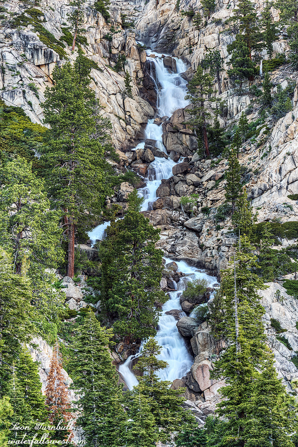
Once I came in view of the big waterfall, I needed to get off this overgrown trail, and cut straight down to the creek. It is steep, and you lose 1200 ft. of elevation, but it is not dangerous and there is a clear enough path going down.
I got all the way down to the creek and found a place to setup my tent. You cannot really see much of the waterfall from creek level, but there is a good view of it from 100 ft. higher up, so after dinner I climbed back up the mountain to take photographs. The total height of the falls is about 300 ft. high. It is a beautiful cascade. It does seem that others have been down in this canyon, but I have not heard of anyone else ever going down here. On this day and night, I was all alone at the bottom of this remote canyon in the Mokelumne Wilderness.

July 4th, 2019 at 7:16 pm
Hi!
I found your post searching for easy backpacking trips in the Sierra that I could do with my children (ages 6 and 10). That waterfall picture is gorgeous! How would I go about getting there?
July 8th, 2019 at 6:30 pm
Hi Baq, this trip is not easy, it is very strenuous. I have info on all waterfalls in California including this one on my website: http://www.waterfallswest.com