DAY 1. THE TORTOISE, THE HARE, AND THE LION
Who wins? The tortoise of course! The lion would much rather eat a nice juicy hare, than an old crusty tortoise. Then the lion will choke to death on the hare-ball (ooh that was a good one, madman). I am the tortoise in this story, by the way. And I win. Read on below.
My solo backpacking adventure begins. It is a long drive to the Southern Sierra trailhead, and it took much longer than expected. The last 60 miles took over two hours to drive, I couldn’t believe it. The last 17 miles in particular were gruelingly slow. The road is paved to Florence Lake, but it is an extremely narrow, one lane road, with many many bumps and bruises on my little Ford Fusion. If I had my SUV, it would have been fine (except for the extremely narrow road which is hair raising when you meet cars coming in the opposite direction), but with my little car, I had to drive 10-20 mph for the most part. I wish I had brought the big vehicle, but I figured that since it was paved, and since it is a popular destination, the road would be fine for the little car. Not!
I wanted to arrive in time to catch the 10:30am ferry across the lake. This would save 4 extra miles (1 way) of tedious, boring hiking along the lake. I arrived at 10:20am. I quickly donned on my hiking boots, grabbed my pack, and ran down to the store. I got there and they told me that the ferry and store were closed for the season (as of the day before!). Ugh! Their website indicates the ferry operates until the end of September, normally, and the weather is perfectly fine, so why would they close for the season now, in the middle of September?
Well no other option presented itself, so I began the hike along the lake. My pack was heavy. Oh my was it ever heavy. Planning for a three night trip, I was carrying a bit more food than last year, and perhaps a bit more clothing, but I think mostly the problem was my camera gear. I probably had 10 pounds of camera gear, and also I might mention that I weigh 10 pounds more than I did last year, so essentially I was carrying 20 more pounds than I should be carrying on a backpacking trip. The whole point of backpacking is to get to more remote spots for photographing waterfalls that I cannot get to on day hikes, so my camera gear is essential for taking good photos of waterfalls. But at the same time, backpacking should be enjoyable, and with heavy camera gear, it is not so much. I will definitely be making a big change on my next backpacking adventure, but I don’t know what it will be yet.
In the meantime, a speed demon hiker came up behind this old tortoise, passing him up easily. I saw many long distance hikers on this trip, some of them hiking from Mammoth Lakes all the way to Mt. Whitney. Yeah, I could do that. Not. Well, maybe with a much lighter pack I could do it. A little while later, I passed the hare, who was sleeping along the trail. (does that sound familiar?) Then he caught me again at Piute Creek. But once again, I passed him in the morning, while he was still sleeping in his tent. The tortoise always wins.
At Piute Creek, I had hiked 12.5 miles thus far, mostly all uphill. It was late in the day, and I was dead tired. I had initially wanted to hike another three miles to Evolution Creek (at least) on the first day. There is no way I could take another step. I was pretty much bonked. I had to stop here. I found a good spot along the SF San Joaquin River. The previous campers had unintentionally left their bear canister here, with food in it, and not closed either. I think they will be in dire straits the next night of their trip. I might have taken the canister with me if I wasn’t already dying from my heavy pack. Anyhow, I set up camp, ate a little dinner, then got ready to go into my tent to sleep.
As I was getting ready to do so, I looked over in the distance and saw some movement. Is that a deer? As I was looking at this, all of a sudden, I saw a cougar come out of the bushes. It was about 200 feet or so away, and moving the other way from me, seemingly stalking the deer or whatever it was (or perhaps that juicy hare). I do not know if he saw me, but it would be hard to miss a bright yellow tent. I saw him very clearly, but it was only for a few seconds, then he was back in the bushes and I did not see him again. If I had not been looking at that precise moment, then I would have missed him. I crawled into my tent for the night with much anxiety, hoping I would not be attacked in my tent in the middle of the night. Do mountain lions do that? Has that ever happened before? I have heard of grizzly bears attacking campers in their tent before, but not lions. Would I be the first such victim? Many such thoughts went through my brain.
Well you would think that I would be scared stupid and thus not able to sleep all night. The truth is, I slept like a baby all night long. That in itself is amazing because normally the first night of camping I never sleep well (even if I don’t see a mountain lion). I guess I was just way too tired from the hike that day, and that overruled how I felt about being attacked by a lion. I just didn’t care.
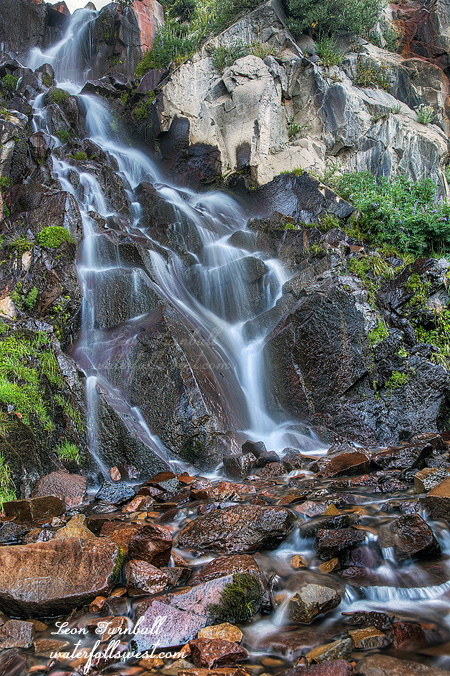
As you can see, I survived the night without incident. I got up very early in the morning, packed up my gear and hiked the three miles up to Evolution Creek Falls. This is where I had initially intended to camp. There were already quite a few backpackers out on the trail this early in the morning, and heading up Evolution Valley but none going over to this waterfall. It is quite an interesting 46 ft. high waterfall, and yet I think most people do not go over to see it or even know it is there, although they do see the upper section of the falls when they go up the trail. It was still flowing quite nicely this late in the season.
So now the question is what would I do next? Even I did not know the answer. Stay tuned.