END OF THE WORLD

Winter is over. Spring is here. It’s the end of the world. (in my view, anyway). Everyone, media and otherwise, is saying that El Nino was so awesome this year, El Nino saved us, El Nino filled all our reservoirs, El Nino gave us a such a large snow pack, El Nino made a huge impact on our drought, El Niño this, El Niño that, blah, blah, blah. Well what do you think? To be honest, I am disappointed. I was expecting a lot more from the super big El Nino. Let’s be very clear: El Nino *did* make an impact on our winter in California. If we did not have El Nino this year, we would have had another awful year, and I am very grateful to God for sending the El Nino to give us drought relief and a decent winter. Nonetheless, we still have serious drought. Southern California had a horrible winter again. El Nino is supposed to make a big impact to southern California, and not so much in the north. In fact, it was the opposite: the north fared much better than the south. What are the numbers? We finished the winter with 125% of average precipitation in the north (less than 100% in the Southern Sierra Nevada). The snow pack results are worse: 97% of normal in the north, 88% in the central, and 72% in the south. So basically, we only had an average winter in the north, and a below average winter in the south. And yet I still hear people complain that we had too much rain this year in California. Are you kidding me? I would have hoped that we would end up well above average from a super El Nino in both the north and south. It gives me trepidation for the future. Next year we will be either ENSO neutral or have a weak La Nina, so does that mean we are back to the drought?
Well enough of that, on to better news …
I knew there was another waterfall above Burstarse Falls. But how could you get up to it? If you think you know the way yourself then you will be disappointed, but if you want to know the proper route, then you will find it on my website.
http://waterfallswest.com/waterfall.php?id=upper-burstarse-falls-890
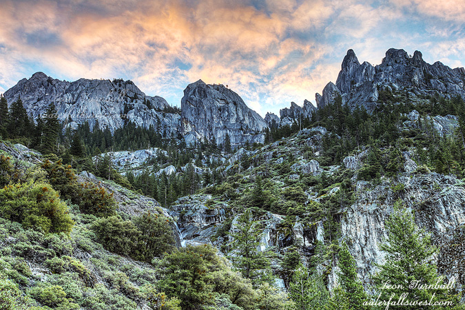
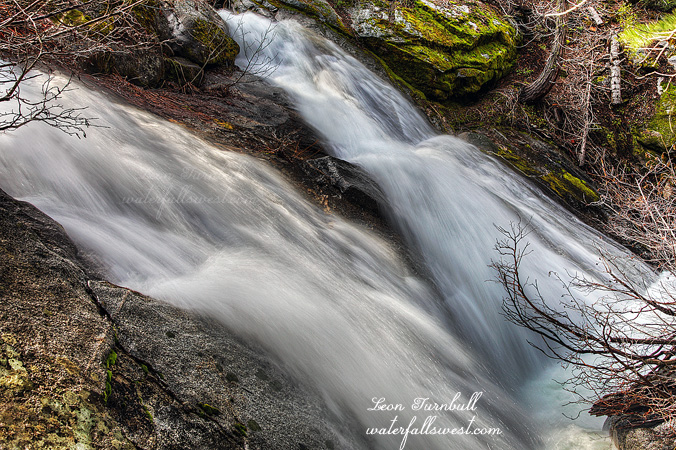
It is a killer climb, very steep, very difficult, very brushy, very crumbly loose rocks, and very cliffy. Did I miss anything? I really did not think I would get anywhere close to the falls. The total elevation gain on the hike is well over 2000 ft. and unfortunately I could not get the view of the waterfall that I wanted because it was too cliffy. No sense in dying just yet. I scrambled around for quite a while, and finally found a side view of the waterfall from the edge of a cliff to get this shot. Well, better this than nothing. It is a sweet looking waterfall slide for sure, 102 feet high, and the view from here is hard to beat with the Crags looming above you and an amazing view of the canyon. It did feel like I was at the end of the world.
It was a tough climb down the mountain, and I was dead tired when I got back to the car but I didn’t break any ankles on those loose rocks (it was close).
The next day, Easter Sunday morning, we were in church service, my kids were sitting in between my wife and I. I was sitting there rubbing my eye like crazy as it was very itchy. My wife is waving at me from the other end of the pew, as if to say what the heck is wrong with you? I’m like, huh? By evening, the verdict was in: My eye was all puffed up. I had poison oak in my eye. Oh crikey! I have only had poison oak in my eye once before, which was probably about 8 or so years ago. That was in both eyes, and it was so bad I had to go to the doctor. At that time, my daughter was very young and thought I was an alien from another planet. She would not go anywhere near me. Thankfully this time, she is older and wiser, and knows I am not an alien (or perhaps I have done well fooling her). Nonetheless, how did I get poison oak? There was no oak on this entire hike that I saw anywhere. I’m thinking it might have been on a different hike. That same afternoon, my wife, brother-in-law, and I went on a short geocaching adventure, and we did see poison oak. I absolutely did not touch it, but it was very “ripe”, just oozing with urushiol oil. At the time, I joked that all I have to do is look at the stuff and I will get poison oak. I seriously think that is what happened. The fumes in the oak leaves must have just wafted up to my eye. Invisible wafting oils? You no doubt think I am crazy, that is not possible, which is what my wife and brother-in-law think, but the only other alternative is I got the oak from the hike in which there was no poison oak. Either way, it is not fun. Oh and at the same time as all this, I have a mysterious bite on my back. It is all puffed up like a tick bite, but there were no embedded ticks, and I did not see any of them on my hike either. Invisible wafting ticks? Most definitely not fun.