It was kind of a lame weekend for me, no new waterfalls to report. You can’t win them all. The hike I really wanted to do was all snowed in. It was only about 5000 ft. in elevation, but the road had too much snow to continue. With this ridiculously warm month, I was surprised I could not drive up this road at least partially. Anyone want to buy me a snowmobile? I could have used one this weekend. I did not have a very great backup plan. I finally gave up all hope and went to Traverse Creek Falls.
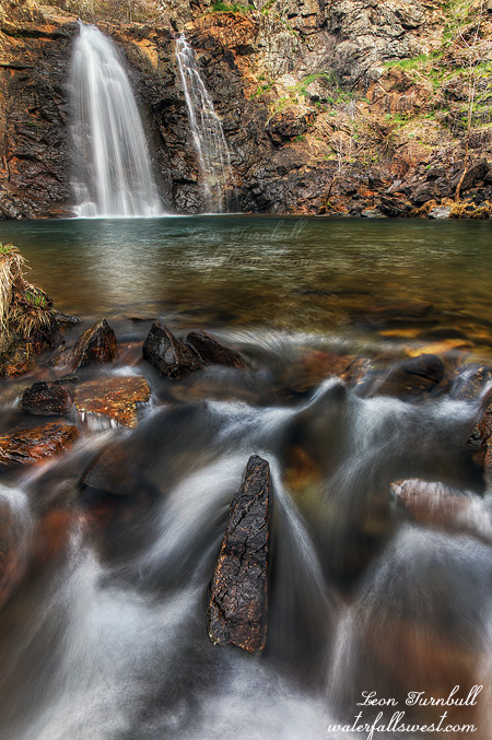
I didn’t really have much desire to go back to Traverse Creek Falls again, but well I was in the area, and had nothing better to do. It is an easy hike, but there are some steep parts. Someone had cut the rope on the first descent. Fortunately, it is not the worst of the steep sections and a rope is not really needed (if you are careful, which of course I was). The second rope at the brink of the falls is still there. Good thing because it is much more treacherous there.
The waterfall was in Double Mode, but just barely. It is almost back to Single Mode after a month of no rain. I expected it to be in Double, but was hoping for a bit more oomph on that second segment. It looks like we may be getting some more of that much needed oomph in March. There is good news, rain is finally back in the forecast. El Nino may be making a comeback. Pray it is a big comeback. Anyhow, I think I got a somewhat different shot of the falls this time, and was standing in the middle of the cold creek to get it.
Whenever I am at Traverse Creek I always bring a garbage bag to pick up trash. In past years there has been a horrible problem here with idiots leaving behind their garbage, but the last couple times I have been here there has been very little to pick up. I was almost ready to declare Traverse Creek “problem” free. Not quite. This time around it seems we are back to square one. I picked up a whole bag of trash. Mostly beer cans, I guess, but a lot of other stuff as well, conveniently thrown into the bushes where all the poison oak is located. If I get poison oak from picking up trash … I will be very unhappy (to put it mildly). I also found a box for a mini cross bow, just left behind at the top of the falls. Really? If you are going to bring something like that on your hike, why wouldn’t you unpack it out of the box at your car? And leave the darn box at your car! If you don’t want to do that, then why can’t you take the box back with you? You packed it in, you can pack it out! Some people’s children. I did have a lovely morning.
Posted in Sacramento, Waterfalls by leapin26: February 28, 2016
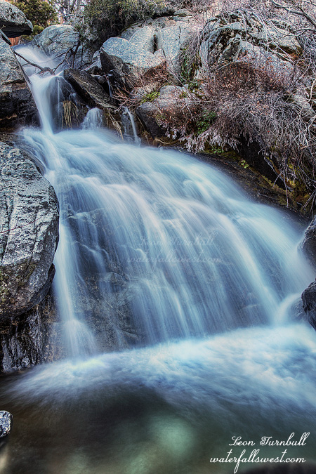
Nice little roadside waterfall here, a very pretty one, 48 ft. high. Normally this creek is dry when I drive by here, but this time it was flowing rather nice. I wish I had more time to explore because I think there could be other falls on this creek, but I had to get out to a different hike. No time to waste.
Click here for more info.
Posted in Northern Sierra, Waterfalls by leapin26: February 27, 2016
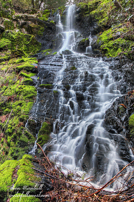
This past weekend I returned again to Moore Creek to further the exploration of that awesome little gem. It is a killer long drive (especially so in winter) – and took about 20 hours to drive it, give or take about 20 hours. I was expecting to find snow from the recent storm, and indeed I did, but fortunately the road was clear of snow, but not clear of potholes. I do believe they plow this road in the winter, at least partially. That is good news because I thought I might not even make it all the way out there, in which case it would have been a big waste of time and gas. Fortunately it was not (a big waste) and I had another fantastic day.
I photographed six waterfalls on this newest adventure: 4 new ones and 2 re-shoots, (plus I re-visited all the waterfalls again on the creek), and yet I still have not completely explored this amazing creek. Indeed, I think I will have to come back at least three more times in the future to complete the exploration of this area. When I do that is the million dollar question, I don’t have much desire to do that long drive again soon, but I imagine I will probably be back sometime in the spring if we get any decent snowmelt this year.
With snow on the ground, I saw that I was following another set of prints up to the waterfalls. It was definitely not Bigfoot. Whoever it was must have been there in the last day or two. I followed the prints the entire hike, to all the falls, and following my GPS route fairly precisely. That’s how I know it was not Bigfoot. Does Bigfoot have GPS? But who was it? A fan of waterfallswest? Please let me know if it was you!
Some interesting tidbits: The creek was flowing a bit stronger than last time I was here, not much but definitely noticeable. Oh yeah, it was also a heckuva lot colder than last time (not that I fell in, or anything like that). I saw that someone had cut down the zipline at the campsite area beside the 21 foot falls (pictured above). Was it the mysterious person whose tracks I was following? Or someone else? It was still distracting, nonetheless, because it was still attached at the top of the falls on the other side of that fast flowing creek. I looked around a bit more at the campsite area. Other things I found: a bunch of interesting wood carvings (what else are you going to do if you are living there all summer?). I did not see any river otters this time, but I did see a bobcat. A big old boy, and I got a good look at him too (from my car and no pics unfortunately – I suppose I should have my camera ready at all times when I am driving, eh). All in all, it was a great day again in the Sierra Nevada.
Posted in Northern Sierra, Waterfalls by leapin26: February 23, 2016
Social media is lighting up this week (literally) with images of the FireFalls – aka Horsetail Falls – in Yosemite National Park. Rightly so, I suppose. It is an amazing natural phenomenon that only occurs for a short time every February, and not every year depending on weather conditions and water flow. This year, however, is a special year, all the conditions have been perfect for the FireFalls. But will you see a FireFalls photo from the Waterfall Madman? No! I say no again!
It is not that it is an uninteresting or crappy waterfall to see. Hardly. Two things I will say: Every single image of Horsetail Falls that I have seen (of the thousands that I have seen) is essentially exactly the same. Some are technically much better than others no doubt, depending on the skill of the photographer, but basically every image is the same. I’m not saying that is a bad thing, necessarily. Do you want your own token shot of Horsetail Falls? I would myself, except for one other thing: All the hundreds of photographers that go there every night in February to see it and photograph it. I hate crowds and I have literally no desire to go duel tripods with hundreds of others lining up at the exact same spot to photograph something in the fleeting moments of sunset. Even go take a look on my website of my photo of Bridalveil Falls from Tunnel View. If you look closely you will see it is indeed *not* at Tunnel View, it is at a different spot. That night, while hundreds of photographers were lined up at Tunnel View, I was at a different spot with one other photographer only. The viewpoint is only slightly different than Tunnel View, and I had a much more pleasant time than all those other photographers battling for a prime shooting spot (and no broken bones from fighting them).
So last weekend while all those hundreds of photographers were lined up at Yosemite for the FireFalls freak show, I was out exploring brand new waterfalls on a new creek, which I had all to myself, no other person within miles of me (literally), and the only living thing that came close to me was a river otter (and some birds, and some squirrels, and perhaps some other small microscopic creatures). I guarantee you I had a much better time that day than I would have had at Yosemite. So get out and explore. There is so much to see. If going with the crowds is your thing, then great, there is nothing wrong with that. But if you’re like me and prefer to be alone in the wilderness, then I say Yahoo, let’s go for it. There are so many awesome places to see in God’s creation, and this is just one of them:
http://waterfallswest.com/waterfall.php?id=moore-creek-falls-1942
Posted in Northern Sierra, Waterfalls, Yosemite by leapin26: February 20, 2016
I’ve been trying to get to a certain waterfall for some time now. I still can’t get it right. I thought for sure it would be flowing from all the warm weather we’ve had this week. Yet once again I found it to be just a trickle. Ugh, what to do now?
I tried a different nearby waterfall that I’ve put off exploring until now. And for good reason, it’s not really much of a falls. It’s also way too much trouble to get to.
It is a tough climb up the mountain (which just happens to be named after the best ski hill in the world – Red Mountain). Once I got up near the falls I found a lot of heavy thick brush. I had to crawl my way through it with a steep drop off below me, and over to the creek. To get over to the bottom of the cascade I then had to cross over one branch of the creek. The rocks in the creek were extremely icy and treacherous and there were more dropoffs below. Well I got to the bottom of the cascade without any broken bones, but I did manage to scratch up my leg enough on that crazy brush to make it bleed – I suppose that is appropriate for Red Mountain. The falls is 26 ft high. There is another tier right below it but I could not get down from here. I had to go back across the treacherous creek, then back through that brush and back down stream. From there I could cross the creek but I was too much below the falls, so I had to climb up the bank on the other side where I found a lot of icy snow. It was soft enough and deep enough that I was breaking through it, so basically I had to crawl up the icy snow bank on my hands and knees to the waterfall (going back down on my butt was much more fun however). Unfortunately there was not much of a view of the lower tier anyway. All that effort and it was not much of a reward. Ah well. It was fun to explore.
Posted in Northern Sierra, Waterfalls by leapin26: February 14, 2016
