It is coming. Maybe. I hope. Perhaps. I’m talking about snow of course. We are still waiting for winter to start here in northern California. The last report I heard is that it is on its way. Mid January things will start to look up. I hope.
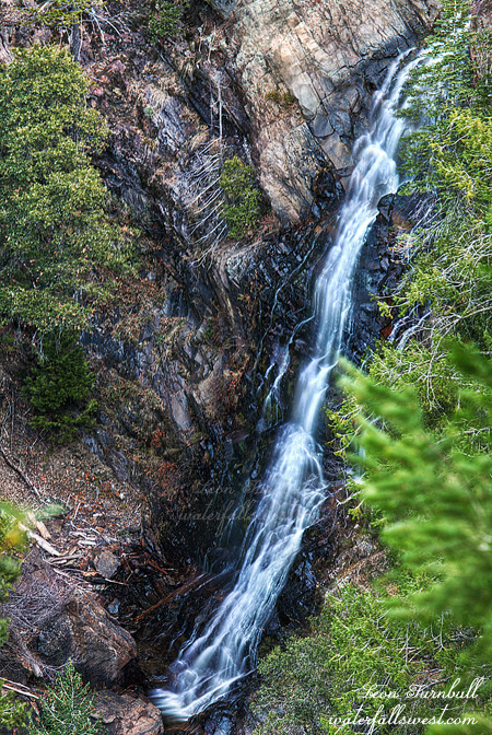
In the meantime, I ventured out to Foresthill looking for a new waterfall on Big Mosquito Creek. With an ominous name like this, I don’t think I would want to come here in the summer. I did not think it would be flowing greatly, but it was more of a scouting trip to return to in the spring (before mosquito season, hopefully). I found the waterfall pretty easily, the viewpoint is just off the main road. Getting down to it is another matter entirely. I did not try this time due to sore ankle and lack of water flow, but I think it is possible, and when I return back in the spring I will definitely give it a go. Another reason I must return is that I am not very happy with this photo. I did not get it in good focus for some reason. Was my I.S. switched on unawares? I did not think so. Ugh. Well, if we do get some snow, then this creek should have great flow in the spring, and the waterfall will be rockin.
Waterfalls, actually. Yes, there is almost certainly a second, much larger waterfall on this same creek downstream. Unfortunately, I think it might not be possible to get down to it. It is about 2 or 3 miles downstream from the upper falls, and after taking a gander at this upper falls, I ventured downstream seeing how close I could get to it. With my ankle still being sore, I did not really want to go too far. Indeed, I went further than I should have, but the going was actually pretty easy and the forest was pretty open, as I think there was a fire that went through here many many years ago. But further down it starts to get very cliffy and that is where I turned around, still a good two miles from the waterfall. From where I turned around, it would have still been possible to continue. But for how long, I do not know. On the way back up, I came to a strange open, flat area. It seemed there was a lot of old bear poop scattered throughout the area, and bear trails going off in different directions. Was this where all the bears in the area hung out? Or slept? Then I heard a strange sound, like a horse. (but obviously, it was not a horse). I do not know what it was, if anything. Maybe a bird. But maybe it was a bear turning over in its sleep. I did not see anything. But I sure did not want to wake up a sleeping bear, so I scooted back up the hill as fast as my sore ankle could take me.
Posted in Northern Sierra, Waterfalls by leapin26: January 8, 2012
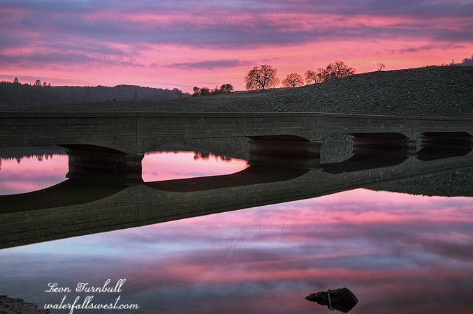
I went hiking after work last night down to Folsom Lake. Not for the sunset. I am trying to lose some more weight, and I figure I need to do more than just one hike per week (on Saturday). It is very difficult to do any sort of exercise after work during the week, since I get home so late. But I am going to try to start doing something at least a few days a week. Going down to Folsom Lake at the old Salmon Falls bridge is an easy but good little hike.
I did take my camera with me (and I plan to keep doing this now, of course!). The sunset initially looked like it would be a wash, nothing at all. There were a lot of thick clouds in the sky. I almost left my tripod in the car. I arrived down at the bridge, which is usually under water, but with the lake being low right now, it is showing. It was sunset time. I did not take my camera out of the bag. I waited. The sky started getting redder. Camera is still in bag. And redder. Still watching. And redder. Now I’m getting intrigued. And redder. Out pops the camera. It was well after sunset by this time, but I quickly setup and took a couple shots. I was definitely not expecting such a sunset, but it was pretty darn sweet. Thanks, Lord.
Posted in Folsom, Sunset by leapin26: December 30, 2011
The weather is all twisted. Winter is supposedly well under way but definitely not for us here in northern CA. After a decent November we had nuthin in December, one of the driest Decembers ever. Initial reports indicated the wet weather would begin in January but now I’m still not seeing too much of anything in the long range forecasts, except for an occasional shower or two. We are probably looking at more dry weather through mid January. Of course we need the rain and snow for more than just the waterfalls. It is our lifeblood in California.
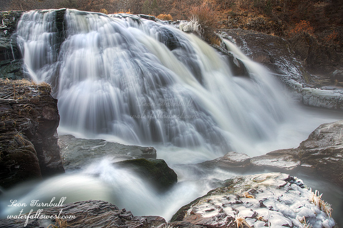
Well, not to be outdone by the dry weather I still wanted to go waterfallin on Christmas Eve on the way up north to visit family. The original plan was to hit Feather Falls, but I just happened to see on dreamflows that PG&E was releasing huge amounts of water in the Pit River and that meant that Pit River Falls would be flowing. Indeed it should be utterly spectacular. Even though it is a four hour drive from my house it would be well worth it and I was going north for Christmas anyway. So up I got at 2:30am and started driving north. I arrived at the Pit River overlook at 7am. Pit River Falls was NOT utterly spectacular. What the hey? This was all twisted, it made no sense. At 5am the gage above Pit 1 Powerhouse was at above 20,000 cubic ft per second. That is mega water flow! But now at 7am it looked to be only at 500 or 600 cfs. What happened? Did they only bring the water level up for a short few minutes? Or was it some sort of error in the gage reading? I do not know. Neither one makes much sense. Well even at 500 cfs the river still has good flow, albeit not spectacular, and I had never been down to the bottom before (not to mention the very long drive out there), so I decided to continue the plan of hiking down to the falls.
If there was an actual well defined trail to the bottom then it would have been easy. There is no trail. There is a path that people have gone down before, but it is very overgrown, there are a lot of branches and twigs you need to walk over, the ground is very rocky and crumbly, and the slope is steep. About 2/3 of the way down I slipped on that crumbly slope and fell, severely twisting my ankle. I heard a pop sound as I fell. Oh oh. It was definitely not broken but it was not good. What should I do? I sat down and recovered myself for five minutes then I decided it was not (and would not be) a show stopper. I continued down to the falls, slowly and gingerly. It was not that bad but I was limping and not putting much weight on the ankle. Coming back up the mountain afterwards was harder but I still made it without too much difficulty. The worst part was the next day, when I was in quite a lot more pain and hobbling around the house worse than my mother in law’s 16 year old cat.
But I made it down successfully to Pit River Falls. The waterfall was nice and with less flow it was easy to climb around on the rocks beside the falls. There were a lot of photo opportunities and I took plenty of photos. Without knowing what the heck was going on with the gage reading I was a bit worried about this, wondering how safe it was down there, and what would happen if they suddenly released a truckload of water over the falls. I watched the river carefully always making sure I had a quick escape route. All in all, it was an enjoyable morning despite the pain, and if you are wondering how my ankle is now, it recovered quite well enough to get back out on the trails on Tuesday.
Posted in Northern CA, Waterfalls by leapin26: December 28, 2011
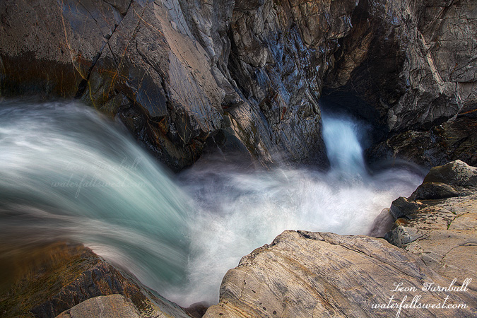
Emerald Pools Take Three.
This weekend they were still releasing water from Lake Spaulding into the South Yuba River so I took one last trip up to see the Emerald Pools on Sunday afternoon after church. (and as it turned out, on Monday morning the faucet was turned off; I got to see it on the last day the river was still running).
I wanted to get down to the lower Emerald Pools on the north side of the river this time and try to get a decent shot of the falls from there.
Along the way I stopped off at the Upper Emerald Pools to attempt to locate my sunglasses where I think I must have dropped them. Could not find them. Bummer.
Continuing on, I made it down to the brink of the lower falls in short order. My goal was to photograph the lower tier of the falls from the north side cliffs (which I did) but what I found much more intriguing was the view looking down the falls from the brink of the upper tier. Incredibly cool. It was actually easy to get right down beside the falls. I got over as close to the edge as I dared (which was pretty close), sat down on the rock, and setup my tripod. The biggest thing I was worried about was dropping my tripod/camera over the brink, but I kept a very tight rein on them. It was quite an exciting location. After this I went along the cliffs to get a good view of the lower tier, then took a shortcut back to my car on Bowman Rd., making it back home by dinner time. It was a great Sunday afternoon.
Posted in Northern Sierra, Waterfalls by leapin26: December 19, 2011
Containing waterfalls of California, Oregon, and Washington. This is a 17×11 photo calendar. The price is $23.99, which may seem expensive but calendars are costly to produce and I am not making much profit on this. The extra large photo size is a really nice bonus. Order this week if you want to get it by Christmas.
Click to Order
Posted in Calendar by leapin26: December 15, 2011