We interrupt our regularly scheduled broadcast (my Kings Canyon trip) to bring you a special report of the Aurora Borealis.
October 10, 2024. The internet world was going nuts because of the anticipated aurora to happen this night. A twice in a lifetime event. The first was exactly five months earlier on May 10 and I messed that one up royally. I did not hear about the aurora until it was too late and I already had made plans for that weekend which I did not want to change. It wasn’t until afterwards that I realized I should have changed my plan. After seeing a few photos of waterfalls under the aurora I determined that is what I need to do. If that event ever happens again. I don’t really care about night photography or the aurora but photographing a waterfall with an aurora, well that is different. That is what the Madman needs to do.
I am not a night owl. I get up very early for work every day and because of this I go to bed very early. That is the way I like it. I do not like staying up late for concerts or parties or whatever. Night photography? Forget it. Even on this day, I did not really want to go out. I wanted to stay home, watch TV, and read. I still had to get up early for work on Friday. I forced myself to get in the car after work and drive up the hill.
My idea? Photograph Horsetail Falls under the Northern Lights. If it was May I would have had many more options, but in October Horsetail Falls is really the only waterfall in my area flowing decent and also facing the right direction (ie. North).
I arrived at the trailhead and hiked up to the falls. It is about a 45 minute hike. No one else had my idea of photographing the waterfall under the Aurora. I had wondered about that. Would I be the only one up there in the dark? It was just me and the wolves and bears. (as an aside I had just read about wolf sightings near Lake Tahoe, very close to where I was – would I see any tonight?). My vision for this night was to photograph a different section of the falls but that section was not flowing too well so instead I went down to the lower section. It was about a half hour before sunset. I set up my camera. I waited.
At 7PM it was dark but there was no Aurora yet. I was beginning to wonder if this was going to work at all. This would be a big colossal waste of time. The color was not going to show up. I prayed. About 5 minutes later I saw my first glimpse of the lights. I started to get ecstatic. I had never seen the Aurora Borealis before tonight. Thank you Lord. This was going to be perfect with the colors directly above the waterfall, just as I had envisioned. For the next 30 minutes I photographed the waterfall and Aurora. After 30 minutes, the color was not getting any stronger so I called it quits and packed up. I heard some of my photographer friends stayed out until midnight. Geez, I thought I was doing great staying out to 7:30PM. For me, the non night owl, it certainly was great. I hiked back to the car in the dark. Obviously, once again I was the last one off the mountain. No Mountain Jesus sighting today. (ha ha). No wolf sightings either. I drove home and was not too late getting into bed. It was an absolutely fantastic evening seeing the Northern Lights in Eldorado National Forest.
I slept for about 10 to 11 hours making up for the 0 hours the previous night. There was a loud bird that woke me in the middle of the night. I do not know what kind it was but I have never heard the sound before. It was cawing constantly and loudly for about an hour.
There were no bugs in the morning and I enjoyed my breakfast in peace. However, they showed up later in the morning as I continued my climb up the trail. I did not lose them until I hit about 7800 ft. in elevation.
There were some pretty fall colors displayed in this section of the trail but mostly all the Aspen trees were well past peak. It was a bit disappointing since it is only Oct. 3. It was a very early season this year for color which is surprising to me since it has been so hot this summer. At one point I came across a hiker resting along the trail and enjoying a particularly beautiful fall color view while smoking a cigarette. Why anyone would want to smoke a cigarette out here is beyond me but I had to take a photo of this amazing view so I apologized as I quickly stepped in front of him to take the shot. He had a French accent and we said hello before I continued up the trail. Little did I know I would see him again multiple times.
I arrived at the Woods Creek suspension bridge at about noon. I would be camping here. The suspension bridge swings crazily and is wild to walk across. And fun. I had to do it a few times. For the camera, you know.
My trip planning is different from most people and I was passed by a lot of people doing the Rae Lakes loop (including my French friend). My primary goal of any trip is to photograph all the waterfalls along the trail in good lighting conditions. Thus I will usually camp near the waterfalls, while others may camp in different spots or hike longer or whatever. Case in point: Woods Creek Falls. 99.9% of the people hiking the Rae Lakes loop will NOT go up to see Woods Creek Falls. It is an extra 5 miles round trip and 1100 ft. of elevation gain. Who in their right mind would do such a thing? Well, the Waterfall Madman of course! Even the PCT hiker I passed as I hiked up to the falls thought I was nuts going up there. He did not say that in so many words but I could read his mind.
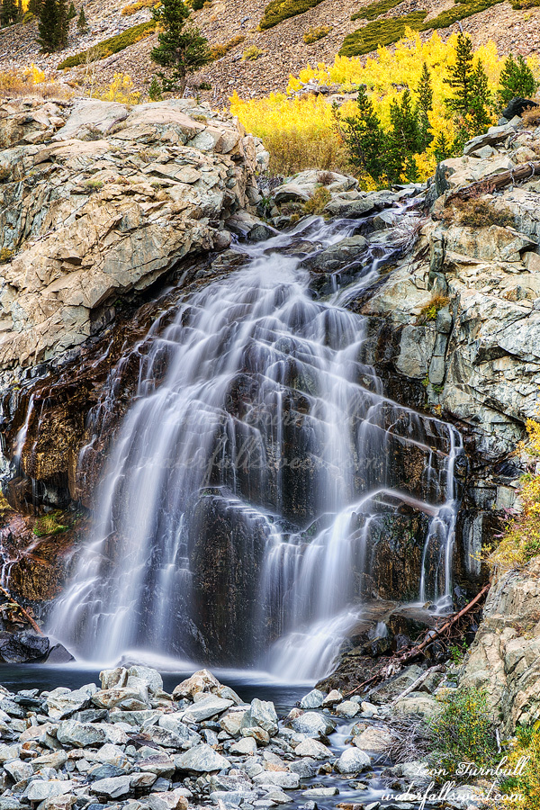
Woods Creek Falls is a beautiful 45 ft. drop right along the trail. Some pretty fall color here as well. I went to the upper falls as well which was not as impressive as I thought it would be. I am pretty sure I could have done the Rae Lakes loop in 4 days instead of 5 if I skipped Woods Creek Falls so was it worth the effort going up here? Well I certainly thought it was. But I’m a madman.
I ran back down the trail and got to camp just after sunset. There was another couple that decided to camp right beside me. There is a whole huge area to camp with no one else around at all and they decided to take the spot right next to me. Why would they do this? It would not have bothered me so much except they were talking noisily as I was trying to sleep. Very annoying and rude. Argh.
With my new job I have to submit vacation requests at least one month in advance. This is a problem for me sometimes. I usually like to plan my backpacking trips within a week or two of the date. I do not know what the weather will be like a month or more in advance. For October trips, there could be rain. There could be snow. There could be fires. Just book it and hope for the best, I guess. One thing that I certainly did NOT expect to be an issue in October: HEAT! It was over 100 degrees in the valley in the first days of October and it still has not let up. This has literally been the summer of hell in California. At least it would not be 100 degrees in the mountains but it was going to be much hotter than I would like and no doubt the bugs would be an issue as well.
Where was my planned trip going to be? The infamous Rae Lakes loop in Kings Canyon National Park. 5 days. 45 miles. 8000 ft. of elevation gain. Majestic mountains. Spectacular lakes. Magnificent scenery. Multitudes of waterfalls. Was this another bucket list hike for me? I suppose it was. It was not at the top of my list but it has been something I’ve wanted to do for a long time now.
I got zero sleep the night before the trip. Maybe a half hour at most. I was up at 2AM. Why so early? A couple reasons but mainly because I wanted to try to get to the first waterfall, Mist Falls, in good lighting conditions. I already have decent photos of this waterfall so I didn’t really need to do this but it’s always nice to re-visit waterfalls and get better photos. It is a very long and tiring drive to the trailhead. I forgot just how long and slow the drive is to Cedar Grove in Kings Canyon NP. It is excruciating. I don’t really want to ever do that drive again but who knows.
I arrived on time at the trailhead (7:30AM) and started the hike. It is 4 miles to Mist Falls. Once you start the last bit up to the waterfall the gnats came out in force. All because of that darn heat this summer. They should be gone by October. How did they compare to Tehipite? Tehipite is the hellish standard in gnat comparison so if Tehipite was a 10 in nastiness then I would say Rae Lakes was an 8. They were bad but thankfully I would not have them for the entire hike. And I had my head net of course.
After Mist Falls I continued on to Upper Paradise Valley. The hike is very difficult due to all the rock steps they built into the trail. Why did they have to do this? Pretty much the entire Rae Lakes loop is horribly built with all these rock steps. It is mostly not necessary and it makes the hike at least five times more difficult. Every single one you have to lift your leg up higher than you should and some of the steps were huge. It was so incredibly tiring. Argh.
I camped the first night at 7000 ft. elevation after hiking 9.0 miles and 1900 ft. elevation gain thus far. The gnats were still out at this elevation but praise the Lord there was a breeze in the afternoon and the bugs left me alone. Until the evening when the breeze stopped but I was going to bed early anyway.
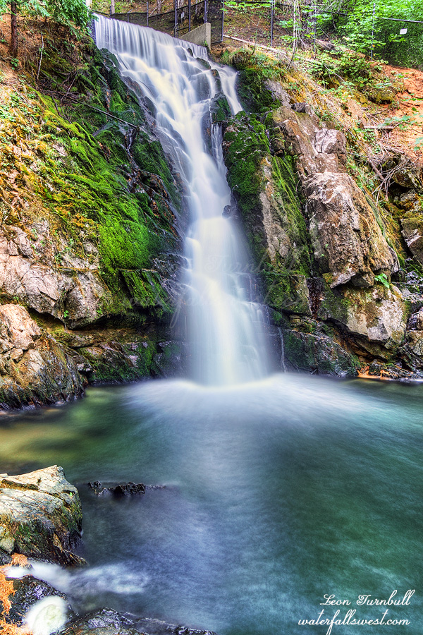
As part of my continuing quest to re-visit waterfalls I have already been to and taking Journey along for the ride, next up on my list: Sly Park Falls. I knew this waterfall was still flowing decent because of a recent photo I had seen. At least I thought it was still flowing. It is a man-made waterfall so they could turn off the tap anytime, even if it was flowing a week ago. Cross fingers and hope for the best, right?
I have been extremely happy with Journey on recent walks. Make no mistake about it: Journey is 1000% a mama’s girl. She lives and breathes for her mama. She will do anything for her mama. That is not to say she does not love her daddy. She loves going to the park with me. Nonetheless, in the beginning she did not really trust me completely and I could not trust her either if I let her off-leash. Slowly, however, she has turned the corner with me. She trusts me now fully. On recent hikes I have let her off leash more and more, and she will stay with me and she will listen to me. She has been absolutely awesome. This makes me very happy. I would hike with our previous dog Kaya off leash all the time and I want Journey to have the same freedom. We are getting there.
The hike to Sly Park Falls was a perfect one for her. It is all on trail, it is not difficult, and there was no one else around so early in the morning. We just saw one jogger on the entire hike. I had her off leash for about 80% of the hike and she was perfect. She stayed with me the entire time, except when she stopped for the occasional sniffing of the flowers and bushes (which Kaya always did as well), but she would always come back to me when I called her. I was so happy. And so was Journey.
Along the way we passed by a forestry workers site. There was a big machine that was running but I saw no people around. Did they just leave it running all night? I think perhaps they were getting ready to work for the day and there was a sign saying do no enter due to the forestry work going on. I suspected that we would not be able to return this same way. Fortunately I did have an alternate way back to the car otherwise it could have been an issue.
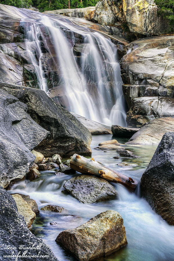
We arrived at the waterfall. It was still flowing very well. Thanks for not turning off the tap, people of the park. In order to get this particular viewpoint without all the tree branches in the way you need to cross the two streams. It was not hard but Journey did not particularly want to cross it, though she did it with no difficulty. We stayed at the waterfall for quite awhile. I took my photos and Journey waited for me patiently. Then she had a good snack before we headed back.
We took a different route. It was a lot steeper. In fact it was almost vertical. I had a very hard time finding purchase for my feet in the loose dirt as I climbed up the mountain. Journey had no such trouble. We got back to the car and drove home. Mama was still sleeping but Journey was happy to wake her up. Wake up mama, I’m home. Let’s play! Ha ha. It was a fantastic morning in Eldorado National Forest.
How many bucket list waterfalls have I been to this year? One, two, three, four. All of them in Yosemite National Park: Eleanor Creek Falls, Ribbon Falls, Kendrick Falls, and … doo doo doo doo … bottom of Illilouette Falls. Four is quite a lot for one year, right? Obviously I’ve been on many other hikes, but I am talking about bucket lists, once in a lifetime hikes, at the top of my list.
I think I have probably mentioned before that I hate the new system in Yosemite where you need to get a day permit reservation in advance. That may work for some people but not me. I cannot plan months in advance when I am going to Yosemite on a certain random day in the future. I usually plan my hikes last minute. I don’t know what the weather is going to be like months in advance, or when I will be able to go on a certain hike, or even what hike I want to do until a few days before. They do release additional permits one week ahead of time, however, on Saturday I am usually hiking so I cannot log on to the computer and try and get a permit in the 10 minutes they are available before they all sell out. This past week, however, I was not doing anything on Saturday so I was actually able to log on and snag a day permit for the following weekend. Goodness gracious me.
I have often wondered why they say you need a permit at 5AM. It is so early! I could go in to the park before 5AM without a permit but that would mean I would have to drive to Yosemite Friday night and find a place to camp or sleep in my car. I don’t really like doing that too much. After 5AM you need to have that darn permit. I arrived at the gate at 5:55 AM. Permit in hand. The kiosk booth was not open! There was no one there! I suspect now that they do not even open until 6AM at the earliest. So why do they say 5AM? Next time I would not even need a permit. Would it be worth taking that chance? Hmmm.
There were a lot of people in the Valley. The Curry Village parking lot was completely full. The trailhead parking lot was almost full. It was only 6:30 AM! Holy crikey.
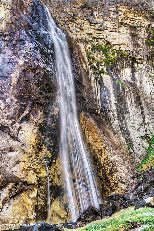
I got my stuff and headed up the trail. I thought the Ribbon Falls hike was very tough (it was). This hike was about three times as difficult. It is about the same length and about the same elevation gain, just a little more. But there is no trail! (unlike Ribbon). It is all off trail. There is brush. There are creek crossings. There is walking right up the creek bed. There is scrambling over huge boulders. There are a couple technical class three maneuvers to get over the huge rocks. It was at the limit of my skill level. It took 2 1/2 hours up and the same going back down. But I made it. The bottom of Illilouette Falls! I would not say it was spectacular but I would certainly say it was incredibly beautiful. (it would be spectacular at high flow but it’s not possible to do this in the spring). Bonus: I saw zero people. Everyone else was hiking the Mist Trail. It was a fantastic morning in Yosemite National Park.