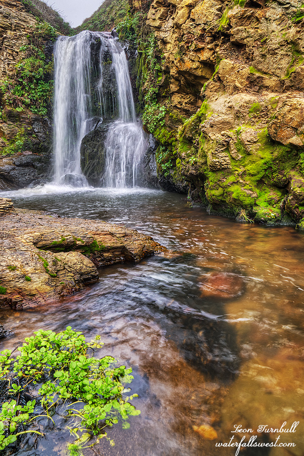
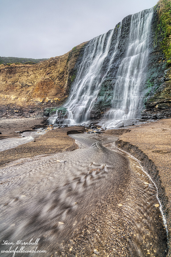
MADMAN ADVENTURES

We had a very late start to the winter this season, definitely the latest start that I can ever remember. I suppose that does not bode well for the snow pack this year, but wait. Last year we also had a very late start, and look what happened that year: our snow pack was about 164% of average at the end of the season. With only one big storm under our belts this year, the numbers for Dec. 1 are now in: rainfall is 50% of average (northern CA), 68% (central Sierra), and 75% (southern Sierra). Snow pack is 76% (north), 94% (central), and 107% (south). So we still have a ways to go to catch up, but hope is not all lost yet. More storms are on the way.

Usually, every Black Friday I go out hiking. It is my thing. It is my favorite day of the year to hike. So I had big plans to hike on Friday, to a couple different places. But … I slept awful on Thursday night and turned my alarm off. I spent the day with family, and figured I would hike on Saturday instead. But … I slept awful on Friday night as well. I almost turned my alarm off again! However, this time I forced myself to get up and out of bed.

I drove up to Oroville and once more back to Bear Ranch Creek. I was really wanting to get up to the upper falls this time, and more than that. I know of only a couple other people that have been up to this upper falls. I have tried before, but it is extremely brushy and difficult. After the Camp Fire decimated this area last year, I thought it would be a lot easier now. Looking at Google Earth, I could see the fire hit this area, and it did not look very brushy anymore. I wanted to try to climb the ridge, instead of going up from the lower falls (which is what you are supposed to do – but that route is very brushy and poison oak as well). The ridge looked like a better option to me. Two problems: One, there was snow! I was not expecting this at all, since this is low elevation (1500 ft.). I was not prepared for snow whatsoever. There would be a huge, steep, and possibly dangerous descent down to the creek. With snow on the ground, it would be very treacherous (I imagined). I figured there was a 90 percent chance I would not make it because of the snow, so this kinda bummed me out since I drove all the way out here to attempt this waterfall, and I had no alternative options. Two, it was too brushy! Indeed, it did not look like there had been a fire at all. It was still just as brushy as before, and there was absolutely no getting through it. It makes no sense because Google Earth clearly shows the fire scorched this area.

I went back down to the trail, and decided to try the other way: Climb up from the lower falls. I have tried this way before, and found it too brushy as well. Well, I will try it again today. It was not very long, and then it dawned on me that I was up much higher than I had made it previously, and I was still going strong. I made it all the way up, and got over to the other side where you need to drop back down to the creek. It was not bad at all, and not dangerous, even in the snow. I made it all the way down, and could see the upper falls before me. It looked amazing! I can’t believe I actually made it all the way this time. I was stoked!

It is really a very gorgeous waterfall, and it is bigger than it looks in photos. I measured the main drop to be 30 ft. high exactly. It is an incredible place. Technically, this should be called the middle falls, not the upper falls. There is definitely another drop above this one. Someday I will get to it. But not today.

It was very tough getting here and took a long time. I was very cold, very wet, and very tired. I still had to climb back up the mountain and down the other side. I made it back down to the car about noon.

But it is not a madman adventure until you have some sort of casualty, and today I had two casualties: I managed to somehow lose my backpack raincover, and I broke my hiking pole. In other words, it was a fantastic day in Plumas National Forest.


No Comments

EIGHT AND COUNTING

This would be the eighth time I have been to Feather Falls in 17 years. It won’t be the last.

In actuality, I was not planning to go to the overlook this time. My plan was to go to the bottom of Feather Falls, on a new route, one that did not involve steep cliffs and abundant poison oak. You may wonder how I would do that. Impossible! Well, I cannot say. Yet. I had a good route mapped out on Google Earth, and I thought it would be golden. However, the route was a washout. There was just too much brush to hack through (surprise surprise). The good thing is there was not much poison oak, but that brush was killer. I tried another way. It too was blocked. Then I tried a third way, and this time I think I found something. However, by now it was too late. There is no possible way I could make it down in time before the waterfall would be in sun, and I did not want to go all the way down and not be able to take photos. So I backtracked, and went to the overlook instead. By the time I got there, the top of the falls was already in sun, but I think I got a pretty good photo nonetheless. I will definitely be back to try my new route. I’m just not sure when that will be.

You will be happy to know that the lower loop of the Feather Falls trail is now completely trash free (for now, anyway). I picked up a ton of garbage on the way back, including a disgusting dirty diaper I found by Frey Creek. I did not want to leave it there, but I had nothing to pick it up with either, so I dumped my lunch into my backpack and then used my lunch bag to store the diaper (picking it up with gloves on). I really think that if you are so lame that you cannot pack out your own trash, you should not be allowed to hike in the wilderness. Am I right? The worst is when people throw their trash off the cliff at the Feather Falls overlook. It is impossible to get down and pick it up. It really irks me to no end. At least leave your stupid trash along the trail so someone else can pack it out for you.


No Comments

THE BIG YUBA

This weekend would be more of a scouting trip than anything else. It is almost mid November and it still has not rained. No rain in the long range forecast. I am depressed. However, I still wanted to go on a hike and find a new waterfall. I was pretty sure this particular waterfall would not be dry, and I hoped it would have decent flow. But would it?

It is a very long drive, I would not want to come out here to see a dry waterfall. The last 3 miles are extremely rough, and I decided to drive them instead of walk. My car did not appreciate it, but my body did when I got back to the car. I would not have to walk an additional 3 miles in the pitch blackness. At least I made sure to put batteries in my head lamp this time.

It is a pretty easy hike to the waterfall, all downhill for 3 miles, and all of it is on a dirt road except for the last part. Coming back up afterwards is a different story, but it is only 1000 feet gain, so it is not really too difficult.

I came to the first crossing of the river, one branch of it. It was completely dry. This is not a good sign. It is obvious that in the spring this branch has tremendous flow, the road is even washed out here from a flood. Perhaps it is from the flood of 2017, or perhaps some other time, I do not know. What I do know is that coming out all this way to see a dry waterfall would make me a very unhappy camper, but this is the smaller branch of the two, so maybe the other one was not dry. This is a river after all, not a creek. I would not expect it to be dry, however it is pretty close to the source so who knows.

As I approached the top of the waterfall, I could hear water. It was not dry! I crossed the river at the top of the falls and made my way down to the bottom on the other side. There was a lot of ice in the river even though it was a very warm day. I thought this was a bit odd.

I was not expecting much, but I had hoped the flow would be a bit better. Nonetheless, it was still very pretty. One very pleasant surprise: the waterfall was much bigger than I expected. When I found this on Google Earth, I estimated it was only about 40 feet high. It is not 40 feet high. It is a towering 69 feet high! In the spring this will be absolutely spectacular. I will definitely come back. It was a very successful scouting trip in Tahoe National Forest.


No Comments

TOTO, I DON’T THINK WE’RE IN CALIFORNIA ANYMORE

It was an extremely windy afternoon and evening.

PG&E had shut off power throughout California due to wildfire prevention. Our church on Sunday morning was without power and we had service in the dark. Despite the power being off, PG&E still started a massive wildfire in Sonoma county. Good thing your new policy works so well, PG&E. Not.

Indeed it was very cold and very windy. It was so windy it felt as if every other tree was going to fall on me as I hiked. It was so windy it felt as if I was being blown clear across the state. There were many fallen branches and twigs on the road (and falling onto the road) as I drove to my destination. It was an obstacle course to avoid them. I do not normally like hiking in such windy conditions. I’m afraid a tree is going to fall on the road and block me in somewhere. Or worse: a tree is going to fall on my car. Or even worse: a tree is going to fall on me. However, I had not hiked in quite a few weeks and I was feeling the big itch to get out into the wilderness.

Most of my hike would be off road. No trail. Just hiking through the woods, with the wind howling and shaking the trees. Thankfully, there was not that much brush I had to whack through. It was mostly open and nice. When I was out in the open, I felt really happy, but the few brushy parts got me anxious for some reason. It was getting late and I did not want to be hiking back in the dark through thick brush. Well it was a nice idea but …

I arrived down at the river after 5PM. It took two hours to hike that two miles through the forest. I was taking a lot of video along the way, which always adds a lot of time to the hike, but I estimated it would take 1.5 hours to hike back to the car. I figured I needed to start back by 5:30pm at the latest to avoid having to hike back in the dark. Hmmm.

Middle Bear River Reservoir Falls is a really nice one, dropping 41 ft. over a big huge rock. It looked very unique and very interesting. I was very pleased. I went to the upper falls last year (also very nice). This year I wanted to try the middle falls, and overall, it was not that difficult to get down to it, and I did not have to cross the river either. I took my photos as quickly as I could. I did not have much time. It was 5:40pm when I started back.

Here’s the problem: Somehow, I totally miscalculated the time for sunset. I had written down in my notes that sunset was at 6:40pm. It was actually at about 6:05pm. I was wondering why it was already so dark as I hiked back up the mountain. I know I am in a deep canyon, but it should not be this dark. By about 6:20pm, it was pitch black (just like the rest of California). I was not even back to the brushy section yet. Now I had to hike through that stuff in the dark, which is exactly what I did not want to do. Not much I can do about it, though. I got out my headlamp. It did not turn on. The batteries were dead. Why did I not check this before my hike! I did not even think I would need it for this hike, which is probably why I did not check it. Well, at least I had my iPhone light. Not quite as nice but it worked. I managed to make it back through the brush and got back to my car at 7PM. It was still extremely windy. Thankfully, no tree had fallen on my car. It was a great little hike at Bear River Reservoir.


No Comments

UPPER KING

I got up in the dark. I got up too early. I totally overestimated how long it would take to hike up to the upper falls. Indeed, it was a pretty short hike. I had calculated that the falls would be in the sun immediately after sunrise, so I wanted to be there at sunrise and no later. But it was not sunrise yet!

When I arrived at the upper falls, it was still dark. I had about 30-45 minutes to wait for sunrise. I could have slept so much longer! Well, I filled up on water and I ate my breakfast. That took about 15 minutes, I suppose. It was quite a bit cold, waiting around with nothing much to do.

Finally, the light came and I was able to take some photos of the waterfall. I had hoped this waterfall would be a bit nicer, but the flow was low. Certainly, it would be spectacular in the spring. Well, it was still quite a bit pretty, even on this day.

I got back to camp, packed up and made some coffee. Then I hiked back down the mountain. I don’t know why because the trail is only about 6 miles, but it took a long time to hike down. (as it did to hike up). Why is that? I was hiking fast (not running or anything, but not going slow either). It just seemed to take so much longer to hike this trail. Made no sense.

Anyhow, I got into Mammoth Lakes, and I found that the power was on. Hallelujah! I stopped at John’s Pizza Works for lunch (as I always do). Then I made the long drive home.

No Comments