Tehipite Madness is a real thing. A real disease. This is a warning. If you continue to read this article, you may catch it. Believe me. It starts off small: a mild curiosity and interest. Over time, perhaps years, it slowly grows and grows, until it becomes an unstoppable torrent of madness. You cannot stop thinking about Tehipite, day and night. The only cure: you must go there. The problem: getting there is no easy task. Tehipite Valley is perhaps the most difficult hike you will ever do in your life. Actually, it is not a debate. It is the most difficult.
In my case, the madness was something even worse.
The madness started about three years ago, I guess. You cannot go to Tehipite in the spring and of course summer is too hot among other things, so the Fall is when you need to go. For waterfalls, that means I needed a big snow year. In 2017, I was not ready to go to Tehipite, physically or mentally (and you need both). My big trip that year was to the North Fork San Joaquin (which was awesome). 2018 was a bad snow year, so that was out. Along comes 2019, another big snow year. Tehipite Valley was my top priority for the Fall this year. The planning was extensive, the madness was building ferociously inside of me. Finally the day came. I’m not sure how ready I was physically or mentally. Even though I had worked my butt off all summer long, I did not lose any weight. I was still at least 10 pounds over what I wanted to be. However, I did feel a lot stronger, so perhaps all the fat just turned into muscle. I don’t know. As for mentally … well ….
My maps told me it was 14.5 miles to the valley. In reality, it was 16.2 miles one way. I do not really understand the big difference, but there are a lot of zigs and zags, I guess, and ups and downs as well. I started hiking at 8:45AM. It took all day to get to the valley, and I arrived at about 5:45pm. Along the way, I met a group of Asian backpackers, only one of whom spoke English. As I approached them, one of the ladies got out her cell phone as I walked up and started taking my picture. What the heck?? I’m not sure how I felt about this. I am not that good looking. I talked to the one guy who spoke my language. He said the trail was in pretty bad condition and very difficult to follow. There was a fire here some years ago and it decimated the trail to Tehipite Valley. I was not surprised to hear this news, but since these people and many others have made it through, I expected I would have no problems either. But he also said something else: the gnats were bad down in the valley. Um, what? Now take note of what he said: the gnats are bad down in the valley. And note what he did NOT say: the gnats down in the valley are absolutely horrific, the gnats are the worst I have ever experienced in my life, the gnats are relentless and will swarm around you without break, and are in the millions. If he had said any of the last three things, I might have re-evaluated my plan. He did not. I can handle a few gnats, geepers, they are probably not that bad anyway. He was wrong about the trail, after all.
Indeed, the trail was not bad at all. There were only TWO extremely short sections where the trail was overgrown and difficult to follow. It was very easy to get by these two short sections. I was expecting so much worse (not just from the Asian backpacker, but from other reports I have read as well). I did not even need my GPS. These people obviously have not done any off trail hiking before. Granted, it would sure be nice if the Forest Service cleared these sections, but really, I have probably done a hundred hikes much worse than this. This one was easy peasy.
After a lot of hiking, and more uphill hiking than I expected or wanted (I’m supposed to be going down!), I finally came to the rim of the Middle Kings Canyon and my first big view. It is a magnificent view. From here you can see the river (3000 ft. below), waterfalls on the opposite side, and of course the majestic Tehipite Dome, which is the reason “most” people want to hike here. “Most” people does not include the waterfall madman, but without a doubt it is a majestic sight to behold.
From here, you descend 3000 ft. to the river in only 2.0 miles. Let us put this in perspective shall we, because remember … if you go down, you sure better be able to climb back up later. The Upper Yosemite Falls trail is 2700 ft. elevation gain in 3.5 miles. That is 771 feet per mile. The Wabena Falls trail is 2600 ft. elevation gain in 2.4 miles. That is 1083 feet per mile. The Tehipite trail is 3000 ft. elevation gain in 2.0 miles. That is a whopping 1500 ft. per mile. This trail is MORE DIFFICULT than Wabena Falls (which was my #1 most difficult hike – before this one). Not to mention that I was carrying a 40 pound backpack (which I did not have for Wabena Falls). By the time I was ready to ascend back again, that pack was supposed to be a lot less than 40 pounds. However …
As I descended from here, the gnats came out. They got worse and worse as I went down the trail. Honestly, I should have had a head net. It would have made things a lot better, but I was not expecting any bugs! It is late September, after all. Of all the reports about Tehipite that I have read, no one mentioned anything about gnats. You would think this would be an important item to mention! By the time, I got down to the valley floor, the gnats were all over me. They were absolutely the worst I have ever experienced in my life, without a doubt. I had hoped that when I got to the open area where I would be camping, they would not be bothersome. Nope! They were horrendous everywhere. I set up my camp, ate my dinner, and went to see the waterfall.
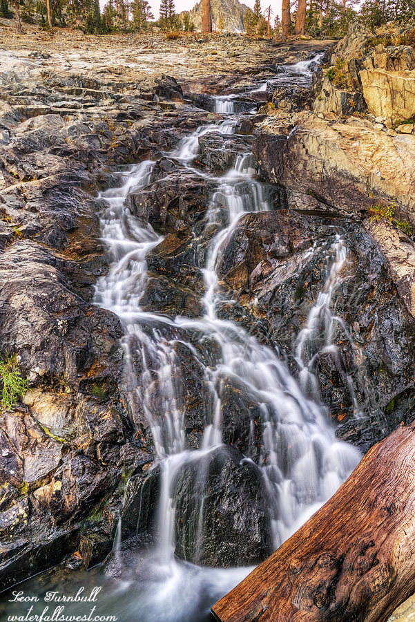
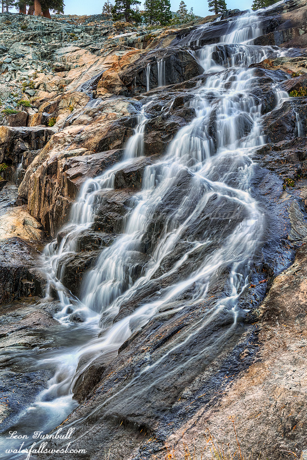
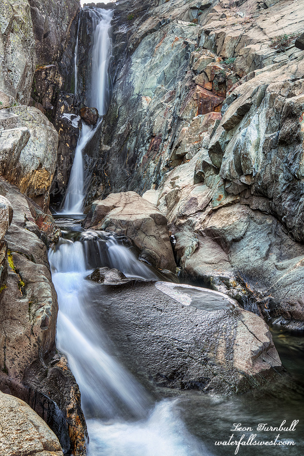
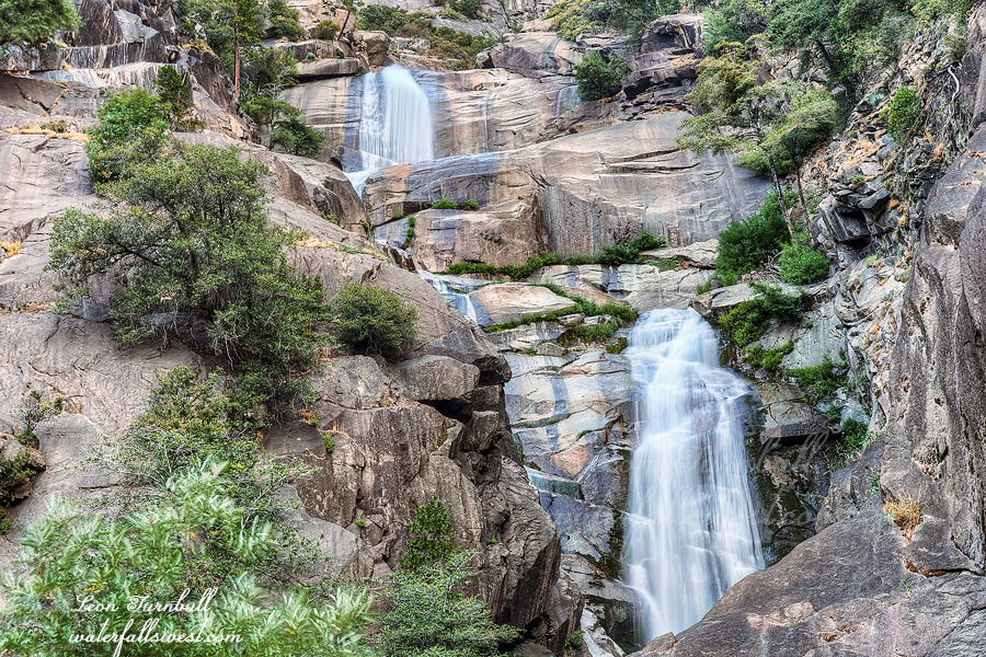
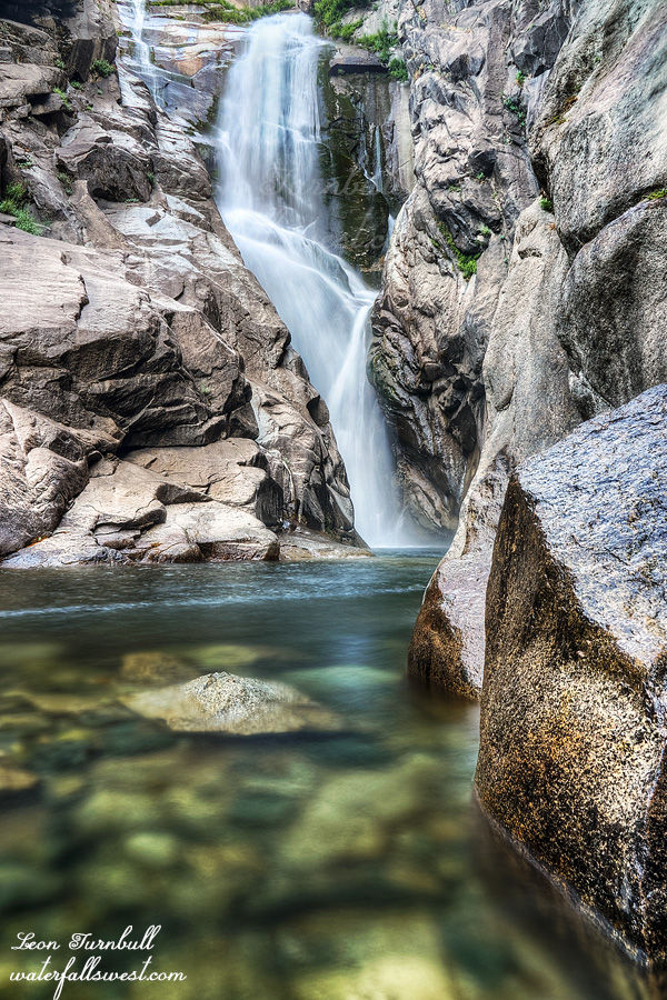
Thankfully, there were no gnats at the waterfall. But unfortunately, there is no place to camp at the waterfall. I should have strung a hammock across the creek at the base of the falls. Ha! To see Silver Spray Falls, you have to cross the creek three times. In late September, it was a challenge crossing the creek. In the spring and early summer, it would be impossible without a doubt. You would not even be able to see the waterfall at that time of year. Even now, this late in the year, the spray at the falls was quite intense, making photography very difficult. I guess that is why they call it Silver SPRAY Falls! Nonetheless, it is an incredibly beautiful waterfall. This lower drop shown here is 160 ft. high, and there are upper tiers as well (the total height is 370 ft.). Silver Spray Falls is worth all the difficulty to see. However, what was I going to do next? …