| Wahclella Falls | Easy |

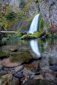
Image 1 of 3; Click arrow to scroll or click image to enlarge |
Location: Columbia River Gorge National Scenic Area, Bonneville, Multnomah County Stream: Tanner Creek Alternate Names: Height: ~130 ft. Access:   Distance: 2.0 miles (RT) Elevation: 50 ft. (+300 ft.) Season: Mar-Oct Form:  Lat/Long:45.61785, -121.95111 Directions:In I-84 east of Portland, take Exit 40 at Bonneville Dam. Drive south to the parking area for Tanner Creek Trail (Wahclella Falls). |


4 Miles E Skamania WA (Elev. 997 ft)
OvernightShowers. Snow level 2800 feet. Low around 38. Calm wind. Chance of precipitation is 80%.
Monday
Showers. Snow level 2500 feet rising to 3100 feet in the afternoon. High near 47. Calm wind becoming southwest around 5 mph in the afternoon. Chance of precipitation is 90%. New precipitation amounts between a tenth and quarter of an inch possible.
Monday Night
A 40 percent chance of showers, mainly before 10pm. Snow level 2900 feet lowering to 2200 feet after midnight . Partly cloudy, with a low around 33. Calm wind.
Tuesday
Showers likely, mainly after 11am. Snow level 2200 feet rising to 3300 feet in the afternoon. Partly sunny, with a high near 47. Calm wind becoming west around 5 mph in the afternoon. Chance of precipitation is 60%.
Tuesday Night
Showers. Snow level 3700 feet lowering to 2600 feet after midnight . Low around 37. West wind 3 to 6 mph. Chance of precipitation is 80%. New precipitation amounts of less than a tenth of an inch possible.
Wednesday
Showers. Snow level 2200 feet rising to 2800 feet in the afternoon. High near 45. Chance of precipitation is 80%.
Wednesday Night
Showers likely, mainly before 11pm. Snow level 3000 feet lowering to 2400 feet after midnight . Mostly cloudy, with a low around 37. Chance of precipitation is 70%.
Thursday
A chance of showers. Snow level 2200 feet rising to 3200 feet in the afternoon. Partly sunny, with a high near 51.
Thursday Night
A slight chance of showers before 11pm. Mostly clear, with a low around 35.
Friday
Sunny, with a high near 58.
Friday Night
Mostly clear, with a low around 40.
Saturday
Sunny, with a high near 63.
Saturday Night
Mostly clear, with a low around 42.
| Munra Falls | 0.62 miles | |
| Upper Munra Falls | 0.72 miles | |
| Upper McCord Creek Falls | 2.29 miles | |
| Elowah Falls | 2.35 miles | |
| Lower Ruckel Creek Falls | 2.55 miles | |
| Metlako Falls | 2.93 miles | |
| Lower Punch Bowl Falls | 2.97 miles | |
| Punch Bowl Falls | 2.98 miles | |
| Loowit Falls | 3.55 miles | |
| Skoonichuk Falls | 3.87 miles | |
| Tenas Falls | 4.08 miles | |
| Dry Creek Falls | 5.24 miles | |
| Tunnel Falls | 5.64 miles | |
| Eagle Creek Falls | 5.80 miles | |
| Horsetail Falls | 6.54 miles | |
| Ponytail Falls | 6.54 miles | |
| Lower Oneonta Falls | 6.82 miles | |
| Middle Oneonta Falls | 6.83 miles | |
| Oneonta Falls | 6.90 miles | |
| Triple Falls | 6.98 miles | |
| Weisendanger Falls | 8.83 miles | |
| Dutchman Falls | 8.87 miles | |
| Ecola Falls | 8.89 miles | |
| Multnomah Falls | 9.22 miles | |
| Fairy Falls | 9.77 miles | |
| Wahkeena Falls | 9.83 miles |
| Columbia River Gorge | Waterfalls Home Page |