DEATH BY TICK

I woke up at 5AM and I was on the trail by 6AM. It was still dark. I had one more waterfall to see, and I needed to get there by 8:30AM.

It took longer than anticipated hiking back down the trail, and I became concerned that I would not make it to the falls in time. Nonetheless, I could not resist stopping for a photo of Mt. Shasta as the rising sun illuminated the mountain so beautifully. When I got back down to the Mud Creek Falls viewpoint, that waterfall was already in the sun, or the top of it was. Would I still have enough time?

I got to the point where (again, as usual for the madman), I had to drop off the trail and into the trees and down the steep mountain side. It was an 800 ft. descent to the bottom of the canyon. This was probably the toughest 800 ft. I have ever descended (or ascended –as it was much tougher going back up afterwards – of course). Same as the Clear Creek trail the previous day, the ground was very soft dirt, but this was even steeper than that trail. It was almost a cliff but not quite a cliff, so it was not deadly, but potential for injury was very high.

Finally I emerged at the bottom, Mud Creek Canyon. Now I had to cross the creek and go upstream to find the waterfall. The creek had very good flow down here, but I was able to rock hop across it, only because there happened to be two very strategically placed large rocks on each side of the creek, otherwise I would have had to get my feet wet. The creek was very muddy (no surprise about that). I placed my hand in the stream and felt a lot of dirt running through my fingers. Yuck. I needed to filter some of this to drink for the hike back up the mountain.

It was an easy hike upstream and I enjoyed walking along Mud Creek very much. It may not be the prettiest creek, but it is a beautiful canyon. I eventually arrived at Lower Mud Creek Falls, a dirty but incredible 50 ft. waterfall dropping off a cliff in a narrow corner of the canyon. I was so excited! I took my time and really enjoyed this beautiful and muddy waterfall. Finally I was ready for the big climb out of the canyon.

The good news is that there was a little side stream at the falls, so I could filter water from there instead of from the muddy creek. The bad news is that there were little ticks in the water, and before I realized this, a few of them got into my water container as I was filling it up. It is not tick season and I had no idea ticks could swim, but they sure looked like ticks and I most assuredly did not want to be swallowing any of them! Imagine if they started biting you from the inside of your throat or stomach. How horrible would it be to die that way? Well, I managed to get them all out of my container and filled it up again in a different spot (with no ticks).

The climb back up the mountain was killer! That is probably obvious. But I need to say again. It was killer! Hiking straight up 800 ft. in soft dirt and unable to get any traction. It took a while. Once back up on the trail, it was a very easy hike back to the car, and then a long drive home. Thanks to my wife who had pizza ready for me when I got home. What a glorious two days in the Mt. Shasta Wilderness.

No Comments

DEATH BY VOLCANO

It has been almost two months since I’ve last hiked. The last one I did was Lake Aloha in the beginning of July. It is now beginning of September. I have been planning for a long time to go to Mt. Shasta this summer, but the fires have put a wrench in my plans. The smoke! The smoke has been horrible throughout the state. Hiking when the smoke is so bad is not smart, and I had to postpone my trip to Shasta because of it, but finally the delta breeze came and blew the smoke away (momentarily). Then the delta breeze stopped a day earlier than it was supposed to and the smoke returned. Should I postpone yet again? I was certain it would be worse the next weekend (the long weekend), so I decided to continue with my plan. Did I make the right call? Yes, I did! It was a fantastic weekend. There was definitely a lot of haze up on the mountain, but the smoke was not bad at all.

The road up to the trailhead is much worse than I remember it. I came to a spot where I could not go any further, even in a four wheel drive. My tires were just spinning in the very soft dirt and I almost got stuck. I backed off and parked by the road and decided to walk from there, about a mile from the official trailhead. I was not the only car that could not make it up. There were quite a few hikers on the trail, all going up to the summit of Mt. Shasta. This is the trail that people use in the late summer to summit the mountain, but I think it is quite sketchy at the top. No matter to me. I had no plans to do that. I was just going up to a little more than 10,000 ft. That was hard enough.

It is a 2000 ft. climb up to the place where I planned to camp. I found a secluded spot well away from the trail and other hikers. When I arrived at camp, I still had no idea what I wanted to do. I was extremely tired from the hike thus far and it was still another 2000 ft. climb to the upper falls; it was also already much later in the day than I anticipated. I setup camp, made my lunch, and tried to rest. But there was no time to rest. If I was going up, I needed to go up now. It was 3:30pm. I only had 3 hours to get up to the falls and I figured it would take that long to reach it. I decided to go. I would never have another chance to do this hike. I just prayed the waterfall would not be dry.

From the camp, the trail does not mess around. It climbs all that 2000 ft. in less than one mile. It is very steep, and the ground is very soft dirt. It is quite difficult to get any traction. The going is very slow but I did not feel that the high elevation was bothering me. 4100 ft. of total climbing today and I felt pretty good. My hike tomorrow would actually be a lot harder and it was at lower elevation (stay tuned). After 10,000 ft. elevation, I needed to get off the main trail and traverse over to the waterfall viewpoint. Across the volcano. The hikers coming down from the summit must have wondered what I was doing, and where I was going. All these people going to the summit and they have no idea there is a waterfall here. Most of them probably don’t even know about the main Mud Creek Falls, because you cannot really see it from the trail. They definitely would have no clue about the upper Mud Creek Falls. The traverse across the volcano was pretty sketchy. The ground was very soft and unstable (worse than on the trail). It was steep. I was worried about triggering a landslide and falling to my death. I prayed there would be no earthquake while I was out here. Imagine 100 tons of dirt and rock falling on your head from above you.

I made it to the waterfall viewpoint. It was about 5:45PM, so I had made very good time. Now I had to wait 45 minutes for the sun to go behind the mountain. I could hear the waterfall (it was not dry!), but I could not see it because the sun was right in my face. I sat down and waited. I ate my dinner, enjoyed the glorious views, watched an eagle soaring above me, and chatted with my wife (I had cell reception). It was so quiet. The only sound I heard was the waterfall and an occasional wind gust.

Finally the sun went down behind the mountain and I could see the waterfall. I had hoped it would be flowing a bit better but it was not bad. It is late summer, after all. All the flow in the creek is coming from the Konwakiton Glacier melting above it. You can also see the Mud Creek Glacier from here. I was a half mile away from the waterfall and this is the closest possible viewpoint. I have only seen one other recent photo of this falls, and it was from further down and much further away. I don’t know that anyone has ever been to this viewpoint before me. It is certainly not very easy to get here. Upper Mud Creek Falls is about 320 ft. high. In the other older images I have seen, over half the waterfall is covered by what looks like a large landslide or perhaps a dirt covered snowfield, making the height of the visible waterfall only 100 ft. high. I had thought this was a permanent fixture but when I was here, that was gone and I saw the full height of the falls. How fascinating.

I took my photos and traversed back across the mountain to the trail and then I booted it back down the hill. I was pretty much sliding down the soft dirt in the steep parts (which was probably not the safest thing to do), but I made very good time and got back to camp right at sunset. It was an amazing day in the Shasta Wilderness and there was still one more day to come.

2 Comments

FAR UPPER CHAMBERS

This is Far Upper Chambers Creek Falls, 81 ft. high. This was my second discovery of the day. And in case, you are wondering, it was just as brushy getting a viewpoint of this one.

No Comments

PAYING THE PRICE

This weekend I went all in to discover two brand new waterfalls in the very upper reaches of Chambers Creek. It was an epic adventure. It was a killer hard adventure. It was a madman adventure.

I started my hike at 9:30am. Not too early. Not too late. I was not in a hurry, and I took much video as I climbed up the mountain. Most people think it is a very difficult hike just to the main waterfalls on Chambers Creek. That was just my half way point on this day. It is a 1700 ft. climb to the main waterfalls. I felt good, and I was not tired as I arrived at the bridge. From here, I had another 1600 ft. to climb up the trail.

This section started out well, but in the the last half of it, the trail became very brushy and overgrown. It is still easy enough to follow, but it was just very annoying. The last time I was up here was about 19 years ago. The trail was not overgrown then. I wonder how many more years, and it will become in-navigable. There was no poison oak, but there were ticks. I got a few on me, but I plucked them off before they did any damage.

As the view opened up, I could see the waterfall in the distance. Well, just part of it. Most of it was hidden. How would I get down to it? To be honest, I thought it unlikely I would make it. The terrain (like most of Chambers Creek) is steep and cliffy. At 5300 ft., I hit the snow line. I expected there to be some snow (as I saw on the satellite images), so I had brought my spikes, but I did not need them. The problem was postholing through the snow and breaking my leg. I took it slow, and soon left the snow behind as I descended down to the waterfall, 500 ft. down. If you are adding up the numbers, that makes a total of 3800 ft. elevation gain for the day. Yikes!  I was tired but I still felt really good before I started the descent down to the creek. This section, though, was killer. I encountered the crazy brush. The brush just got worser and worser as I descended closer to the falls (is worser a word? it should be a word). It was very difficult to battle through it, but battle through it I must. I was too close to turn back now. After a great deal of effort, I finally saw the ridge I wanted to get to. Until this point, I could not even see it because of all the brush, and yet, there was still a huge mound of the stuff to get through before I could get there. Finally, I reached the ridge overlooking the waterfall. I could not see the waterfall. Well, I could see it but it was obscured because of trees in the way. Well this sucks.  I had to descend more, down the cliff. I used my rope to get down, and shortly arrived at a much better viewpoint, with a clear view of the falls.

Upper Chambers Creek Falls is a real beauty, 145 ft. high in two large tiers. I took photos and ate my lunch, and examined my injuries. My legs were completely scratched up and in pain from scrambling through all that brush. (you say I should have worn long pants – well that would have been actually smart). I definitely paid the price on this hike, and it was much tougher going back up. I also made another stop at a second waterfall along the way (pic coming soon). When I finally got back to the trail, it was 4PM. Now I was spent. I still had 4 miles to hike and 3300 ft. to descend. At least it was all downhill. I arrived back at the car a bit before 6PM, just as it was getting dark. It was an awesome day in Plumas National Forest, but I will not ever be back to see this one again.

No Comments

FEBRUARY UPDATE

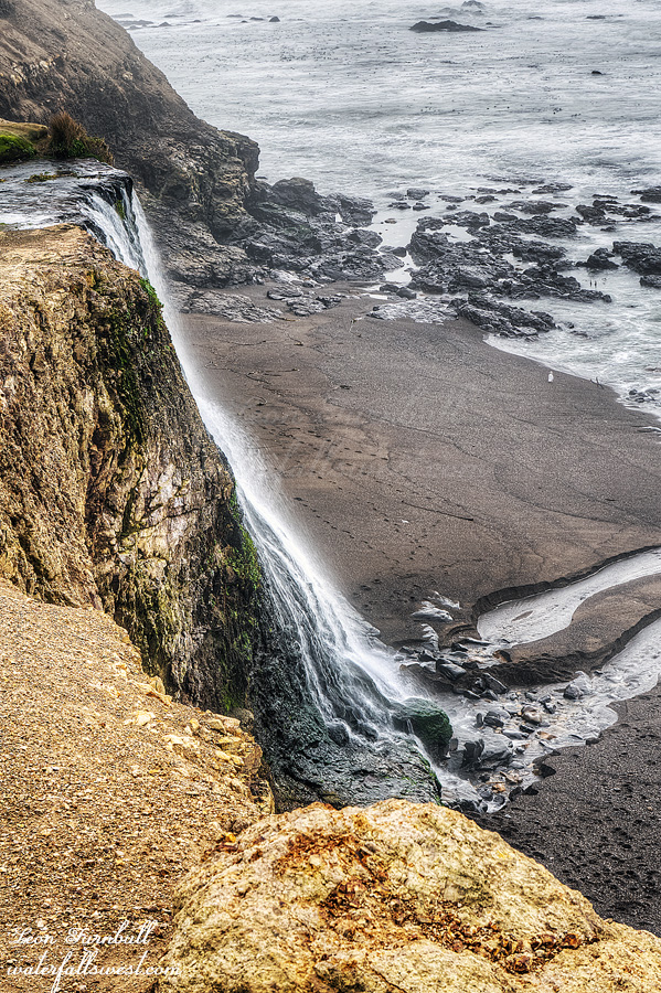
This is Alamere Falls from the cliffs. You don’t want to stand too close to the edge here.

As of Feb. 1, the snow pack is 77% of normal (northern CA), 71% (central Sierra), 69% (southern Sierra). Rainfall is 63% (north), 53% (central), 55% (south). Things are looking very bleak this year. I like to be optimistic, however. Optimistic that we will catch up in the last half of February and March, and get back to average by the end of winter. Pray for snow, everyone.

No Comments