| Nevada Falls | Strenuous |

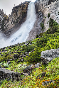
Image 1 of 3; Click arrow to scroll or click image to enlarge |
Location: Yosemite Village, Yosemite National Park, Mariposa County Stream: Merced River Alternate Names: Height: 594 ft. Access:   Distance: 6.4 miles (RT) Elevation: 4000 ft. (+2000 ft.) Season: Apr-Jul Form:  Lat/Long:37.72496, -119.53249 Directions:On Southside Drive, drive to Curry Village and park. Then take the free shuttle to Happy Isles, stop #16. Start walking up the paved trail to Nevada Falls. |


2 Miles S Yosemite CA (Elev. 7730 ft)
TodaySnow showers. The snow could be heavy at times. Some thunder is also possible. High near 34. Wind chill values as low as 17. Breezy, with a west southwest wind 20 to 25 mph, with gusts as high as 35 mph. Chance of precipitation is 100%. Total daytime snow accumulation of 8 to 12 inches possible.
Tonight
Snow showers before 8pm, then snow, mainly after 8pm. The snow could be heavy at times. Some thunder is also possible. Low around 18. Wind chill values as low as 10. Breezy, with a west southwest wind 15 to 20 mph decreasing to 5 to 10 mph after midnight. Winds could gust as high as 25 mph. Chance of precipitation is 100%. New snow accumulation of 6 to 10 inches possible.
Tuesday
Snow, mainly after 11am. The snow could be heavy at times. High near 27. Wind chill values as low as 13. Southwest wind 5 to 15 mph. Chance of precipitation is 90%. New snow accumulation of 6 to 10 inches possible.
Tuesday Night
Snow, mainly before 11pm. The snow could be heavy at times. Low around 17. Wind chill values as low as 10. West southwest wind 5 to 10 mph, with gusts as high as 15 mph. Chance of precipitation is 80%. New snow accumulation of 3 to 5 inches possible.
Wednesday
A 20 percent chance of snow after 11am. Mostly sunny and cold, with a high near 32. West wind around 5 mph.
Wednesday Night
Mostly cloudy, with a low around 19. West wind around 5 mph becoming east in the evening.
Thursday
A 20 percent chance of snow after 11am. Mostly sunny, with a high near 35. East wind around 5 mph becoming west southwest in the afternoon.
Thursday Night
Partly cloudy, with a low around 23. West wind 5 to 10 mph becoming east northeast in the evening.
Friday
Sunny, with a high near 41. East northeast wind 5 to 10 mph becoming southwest in the morning.
Friday Night
Mostly clear, with a low around 26. West wind 5 to 10 mph becoming east northeast after midnight.
Saturday
Sunny, with a high near 45. East northeast wind 5 to 10 mph.
Saturday Night
Mostly clear, with a low around 30. North wind 5 to 10 mph becoming east northeast in the evening.
Sunday
Sunny, with a high near 49. East northeast wind 5 to 10 mph.
| Silver Apron Falls | 0.50 miles | |
| Vernal Falls | 0.62 miles | |
| Lower Illilouette Falls | 1.42 miles | |
| Illilouette Falls | 1.71 miles | |
| Staircase Falls | 2.36 miles | |
| Tenaya Falls | 2.42 miles | |
| Royal Arch Cascade | 2.65 miles | |
| Snow Creek Falls | 2.80 miles | |
| Merced River Falls | 2.85 miles | |
| Sentinel Falls | 3.40 miles | |
| Clark Fork Falls | 3.55 miles | |
| Lehamite Falls | 3.56 miles | |
| Bunnell Cascade | 3.61 miles | |
| Lower Yosemite Falls | 3.86 miles | |
| Upper Yosemite Falls | 4.05 miles | |
| Lower Pywiack Cascade | 4.64 miles | |
| Pywiack Cascade | 4.90 miles | |
| Echo Creek Falls | 5.41 miles | |
| Horsetail Falls | 5.55 miles | |
| Silverlace Falls | 5.67 miles | |
| Bridalveil Falls | 6.10 miles | |
| Ribbon Falls | 6.20 miles | |
| Upper Tenaya Creek Falls | 6.62 miles | |
| Widows Tears | 7.18 miles | |
| Silver Strand Falls | 7.40 miles | |
| Lower Washburn Lake Falls | 8.08 miles | |
| Tioga Pass Falls | 8.77 miles | |
| Upper Washburn Lake Falls | 8.91 miles | |
| Sacred Pool Falls | 9.36 miles | |
| Cascades | 9.58 miles | |
| Tamarack Falls | 9.74 miles | |
| Wildcat Falls | 9.80 miles | |
| Merced Peak Fork Falls | 9.95 miles |
| High Sierra | Waterfalls Home Page |