|
|
Moderate |

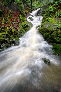
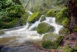
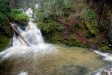
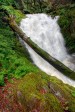
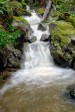
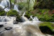
Image 1 of 9; Click arrow to scroll or click image to enlarge Upper Section of Fall #1 (72 ft.) |
Location: Fairfax, Mt. Tamalpais, Marin Municipal Water District, Marin County Stream: Cataract Creek Alternate Names: Height: various Access:   Distance: 2.6 miles (RT) Elevation: 650 ft. (+1050 ft.) Season: Dec-May Form:  Lat/Long:37.93209, -122.63551 Directions:Take Hwy #101 to San Rafael, and take the Sir Francis Drake Blvd. exit. Drive 6 miles to Fairfax, and turn left on Pacheco Rd. (may be unsigned, there is a sign saying "Fairfax" at intersection). Take an immediate right on Broadway, then first left on Bolinas Rd. Drive 7.8 miles to Alpine Lake, and park at the hairpin turn just after crossing the dam. Parking is limited, find a parking spot somewhere off the narrow road. The trailhead is on the left at the hairpin turn. Alternatively, you can park at the other end of the trail, on West Ridgecrest Blvd. at the Laurel Dell picnic area. From the Mill Valley / Stinson Beach / Hwy #1 exit on Hwy #101 north of San Francisco, drive 1 mile to Shoreline Hwy. Turn left and drive 2.5 miles to Panoramic Hwy. Turn right and drive 5.2 miles to Pantoll Rd. Turn right and drive 1.4 miles to Ridgecrest Rd. Turn left and drive 1.6 miles to a small parking area on right. The trail is marked "Laurel Dell". |


4 Miles ENE Bolinas CA (Elev. 797 ft)
TonightRain. The rain could be heavy at times. Low around 51. South wind around 21 mph, with gusts as high as 49 mph. Chance of precipitation is 100%. New precipitation amounts between 1 and 2 inches possible.
Thursday
Rain. High near 57. South wind 14 to 20 mph, with gusts as high as 40 mph. Chance of precipitation is 90%. New precipitation amounts between three quarters and one inch possible.
Thursday Night
Rain. The rain could be heavy at times. Low around 54. South wind around 18 mph, with gusts as high as 44 mph. Chance of precipitation is 80%. New precipitation amounts between a half and three quarters of an inch possible.
Friday
Rain. The rain could be heavy at times. High near 61. South wind 14 to 18 mph, with gusts as high as 39 mph. Chance of precipitation is 100%. New precipitation amounts between 1 and 2 inches possible.
Friday Night
Rain. Low around 51. Southwest wind 7 to 9 mph, with gusts as high as 21 mph. Chance of precipitation is 100%. New precipitation amounts between a tenth and quarter of an inch possible.
Saturday
Rain likely, mainly before 10am. Partly sunny, with a high near 60. Chance of precipitation is 60%. New precipitation amounts of less than a tenth of an inch possible.
Saturday Night
Rain likely, mainly after 10pm. Mostly cloudy, with a low around 48. Chance of precipitation is 60%.
Sunday
Rain likely. Mostly cloudy, with a high near 58.
Sunday Night
Rain likely. Mostly cloudy, with a low around 49.
Monday
Rain. Mostly cloudy, with a high near 60.
Monday Night
Rain. Mostly cloudy, with a low around 50.
Tuesday
Rain likely. Mostly cloudy, with a high near 60.
Tuesday Night
A chance of rain. Mostly cloudy, with a low around 50.
| Morses Gulch Falls | 1.60 miles | |
| West Fork Lagunitas Creek Falls | 1.93 miles | |
| Carson Falls | 2.65 miles | |
| Steep Ravine Falls | 2.65 miles | |
| South Fork San Anselmo Creek Falls | 3.31 miles | |
| Bill Williams Creek Falls | 3.61 miles | |
| Cascade Falls | 3.69 miles | |
| Upper Cascade Falls | 3.90 miles | |
| Dawn Falls | 3.95 miles | |
| White Hill Falls | 3.96 miles | |
| Cascade Falls | 3.96 miles | |
| Big Carson Falls | 4.52 miles | |
| Warner Falls | 4.88 miles | |
| Bolinas Point Falls | 5.23 miles | |
| RCA Beach Falls | 5.23 miles | |
| Arroyo Hondo Falls | 5.39 miles | |
| Loma Alta Falls | 5.71 miles | |
| Palomarin Falls | 6.38 miles | |
| South Bass Falls | 7.02 miles | |
| Bass Falls | 7.05 miles | |
| Mountain View Falls | 7.95 miles | |
| Upper Alamere Falls | 7.98 miles | |
| Alamere Falls | 7.98 miles | |
| Rubicon Creek Falls | 8.13 miles | |
| Stairstep Falls | 8.43 miles | |
| Pacheco Creek Falls | 9.10 miles | |
| Lower Pacheco Creek Falls | 9.12 miles | |
| Arroyo San Jose Falls | 9.28 miles | |
| Phantom Falls | 9.30 miles | |
| Little Pacheco Valley Falls | 9.36 miles | |
| North Phantom Falls | 9.58 miles | |
| Horsetail Falls | 9.78 miles |
| San Francisco Bay | Waterfalls Home Page |
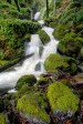
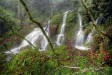
Cataract Falls
5.0 out of 1 reviews